当前位置:
X-MOL 学术
›
Nat. Commun.
›
论文详情
Our official English website, www.x-mol.net, welcomes your
feedback! (Note: you will need to create a separate account there.)
Hard rock landforms generate 130 km ice shelf channels through water focusing in basal corrugations.
Nature Communications ( IF 14.7 ) Pub Date : 2018-11-01 , DOI: 10.1038/s41467-018-06679-z Hafeez Jeofry , Neil Ross , Anne Le Brocq , Alastair G.C. Graham , Jilu Li , Prasad Gogineni , Mathieu Morlighem , Thomas Jordan , Martin J. Siegert
Nature Communications ( IF 14.7 ) Pub Date : 2018-11-01 , DOI: 10.1038/s41467-018-06679-z Hafeez Jeofry , Neil Ross , Anne Le Brocq , Alastair G.C. Graham , Jilu Li , Prasad Gogineni , Mathieu Morlighem , Thomas Jordan , Martin J. Siegert

|
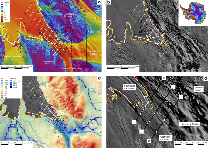
Satellite imagery reveals flowstripes on Foundation Ice Stream parallel to ice flow, and meandering features on the ice-shelf that cross-cut ice flow and are thought to be formed by water exiting a well-organised subglacial system. Here, ice-penetrating radar data show flow-parallel hard-bed landforms beneath the grounded ice, and channels incised upwards into the ice shelf beneath meandering surface channels. As the ice transitions to flotation, the ice shelf incorporates a corrugation resulting from the landforms. Radar reveals the presence of subglacial water alongside the landforms, indicating a well-organised drainage system in which water exits the ice sheet as a point source, mixes with cavity water and incises upwards into a corrugation peak, accentuating the corrugation downstream. Hard-bedded landforms influence both subglacial hydrology and ice-shelf structure and, as they are known to be widespread on formerly glaciated terrain, their influence on the ice-sheet-shelf transition could be more widespread than thought previously.
中文翻译:

坚硬的岩石地貌通过集中在基础波纹中的水产生130公里的冰架通道。
卫星图像显示出与冰流平行的基础冰河上的水流条纹,以及冰架上蜿蜒的特征,这些特征横切了冰流,并被认为是由于水从结构良好的冰河系统中流出而形成的。在这里,穿透冰的雷达数据显示了在地下冰层下方与水流平行的硬床地貌,以及在蜿蜒的地面通道下方向上切入冰架的通道。当冰过渡到浮选时,冰架上会合并起因于地形的褶皱。雷达揭示了地貌旁边存在冰川下的水,这表明排水井井井有条,其中水作为点源从冰原中流出,与空腔水混合并向上切成波纹峰,从而加剧了下游的波纹。
更新日期:2018-11-02
中文翻译:

坚硬的岩石地貌通过集中在基础波纹中的水产生130公里的冰架通道。
卫星图像显示出与冰流平行的基础冰河上的水流条纹,以及冰架上蜿蜒的特征,这些特征横切了冰流,并被认为是由于水从结构良好的冰河系统中流出而形成的。在这里,穿透冰的雷达数据显示了在地下冰层下方与水流平行的硬床地貌,以及在蜿蜒的地面通道下方向上切入冰架的通道。当冰过渡到浮选时,冰架上会合并起因于地形的褶皱。雷达揭示了地貌旁边存在冰川下的水,这表明排水井井井有条,其中水作为点源从冰原中流出,与空腔水混合并向上切成波纹峰,从而加剧了下游的波纹。


 京公网安备 11010802027423号