International Journal of Applied Earth Observation and Geoinformation ( IF 7.6 ) Pub Date : 2018-09-07 , DOI: 10.1016/j.jag.2018.08.027
Yosef Mengistu Darge , Binyam Tesfaw Hailu , Ameha Atnafu Muluneh , Tesfaye Kidane
|
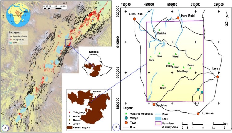
Despite the high geothermal potential of the Main Ethiopian Rift (MER), risks associated with the industry and the difficulty of identifying possible targets using ground surveys alone continue to impede the development of geothermal power diligence in Ethiopia. In this paper, we investigate the geothermal potential of the Tulu Moye prospect area in the MER using Landsat 8, which is an important and cost-effective method of detecting geothermal anomalies. Data with a path/row of 168/054 were obtained from the Landsat 8 Operational Land Imager (OLI) and Thermal Infrared (TIR) sensors for October 17, 2014. Based on radiometric calibration, atmospheric correction (with the 6S model) and an NDVI-based threshold method for calculating land surface emissivity, a split-window algorithm was applied to retrieve the land surface temperature (LST) of the study area. Results show LST values ranging from 292.2 to 315.8 K, with the highest values found in barren lands. A comparison of LST between the Moderate Resolution Imaging Spectroradiometer (MODIS) and Landsat 8 shows a maximum difference of 1.47 K. Anomalous areas were also discovered, where LST was about 3-9 K higher than the background area. We identified seven of these as areas of high geothermal activity in the Tulu Moye prospective geothermal area. Auxiliary data and overlay analysis tools eliminated any non-geothermal influences. The research reveals that the distribution of highy prospective geothermal areas is consistent with the development and distribution of faults in the study area. Magmatism is the thermal source and faults provide conduits for the heat to flow from earth’s interior to the surface, facilitating the presence of geothermal anomalies. Finally, TIR remote sensing methods prove to be a robust and cost-effective technique for detecting LST anomalies in the geologically active area of MER. Moreover, combining TIR remote sensing with knowledge of the structural geology of the area and geothermal mechanisms is an efficient approach to detecting geothermal areas.
中文翻译:
使用埃塞俄比亚大裂谷图卢莫耶地热远景中的Landsat 8 TIRS数据探测地热异常
尽管埃塞俄比亚主要裂谷(MER)具有很高的地热潜力,但与该行业有关的风险以及仅凭地面勘测难以确定可能的目标,仍继续阻碍埃塞俄比亚地热发电努力的发展。在本文中,我们使用Landsat 8研究了MER中Tulu Moye勘探区的地热潜力,这是一种检测地热异常的重要且经济高效的方法。路径/行数为168/054的数据来自2014年10月17日的Landsat 8操作性陆地成像仪(OLI)和热红外(TIR)传感器。基于辐射定标,大气校正(使用6S模型)和基于NDVI的阈值方法,用于计算地表发射率,使用分割窗口算法检索研究区域的地表温度(LST)。结果显示LST值在292.2至315.8 K之间,在贫瘠土地中发现的最高值。中分辨率成像光谱仪(MODIS)与Landsat 8之间的LST比较显示最大差异为1.47K。还发现了异常区域,其中LST比背景区域高约3-9K。我们确定了其中七个是图卢莫伊潜在地热区中地热活动高的地区。辅助数据和覆盖分析工具消除了任何非地热影响。研究表明,高度预期的地热区的分布与研究区断层的发育和分布是一致的。岩浆作用是热源,断层提供了热量从地球内部流到地面的管道,从而促进了地热异常的存在。最后,TIR遥感方法被证明是一种用于检测MER地质活动区域中LST异常的稳健且具有成本效益的技术。此外,将TIR遥感与该区域的结构地质知识和地热机理相结合,是检测地热区域的有效方法。


 京公网安备 11010802027423号