当前位置:
X-MOL 学术
›
J. Clean. Prod.
›
论文详情
Our official English website, www.x-mol.net, welcomes your
feedback! (Note: you will need to create a separate account there.)
Habitat networks simulation and sustainable optimization policies for sectional functional impairments based on “land – Species” coupling
Journal of Cleaner Production ( IF 9.7 ) Pub Date : 2024-12-17 , DOI: 10.1016/j.jclepro.2024.144513 Zihan Zhang, Cheng Wang, Yonglian Qian, Qiuyue Zhang, Chaoran Song, Qingyu Li, Yutong Wu, Bin Dong
Journal of Cleaner Production ( IF 9.7 ) Pub Date : 2024-12-17 , DOI: 10.1016/j.jclepro.2024.144513 Zihan Zhang, Cheng Wang, Yonglian Qian, Qiuyue Zhang, Chaoran Song, Qingyu Li, Yutong Wu, Bin Dong

|
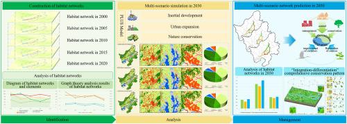
The middle and lower reaches of the Yangtze River is an important stopover along the East Asian-Australasian Flyway. But this region is also a rapidly developing area in terms of economic level. The construction and simulation of the endangered species habitat network will be beneficial for future regional species habitat conservation and human activity management. The conservation and management also contribute to advancing the United Nations’ 2030 Sustainable Development Goals and the conservation of biodiversity hotspots. Therefore, based on crane habitats and environmental data in 2000∼2020, the study used circuit theory and PLUS model to construct (2000–2020) crane habitat networks and simulate (2030) land use data. Then, the study predicted the habitat networks in 2030. The results indicated that: (1) The sources from 2000 to 2020 were mainly distributed in Caizi Lake, Shengjin Lake, and Longgan Lake. From 2000 to 2020, the area of sources reduced from 103.48 km2 to 52.61 km2 which decreased by 49.16%. The number of corridors decreased by 48.15%. The total length of corridors decreased by 47.69%. The integrity of the habitat networks was weakened. (2) In 2030, the area of shoal increased by 0.77% in nature conservation scenario. In inertial development and urban expansion scenarios, construction land increased by 6.50% and 23.80%, respectively, mainly located in the northern area of Caizi Lake. (3) In nature conservation scenario, the number of sources increased from 7 to 10 relative to inertial development and urban expansion scenarios, and the number of corridors increased by 28.57% relative to 2020. The network closure index (α) in nature conservation scenario was 0.60 which was better than inertial development (0.56) and urban expansion (0.44) scenarios. Therefore, this study proposed sustainable optimization policies for sectional functional impairments of crane habitat networks based on the nature conservation scenario in 2030. It will provide an important reference for crane habitat conservation and wetlands structural restoration in the middle and lower reaches of the Yangtze River.
中文翻译:

基于“土地-物种”耦合的断面功能障碍栖息地网络模拟和可持续优化策略
长江中下游是东亚-澳大拉西亚迁徙路线沿线的重要中转站。但就经济水平而言,该地区也是一个快速发展的地区。濒危物种栖息地网络的构建和模拟将有利于未来的区域物种栖息地保护和人类活动管理。保护和管理还有助于推进联合国 2030 年可持续发展目标和保护生物多样性热点。因此,基于 2000—2020 年的鹤类栖息地和环境数据,本研究采用电路理论和 PLUS 模型构建了 (2000–2020) 鹤类栖息地网络并模拟了 (2030) 土地利用数据。然后,该研究预测了 2030 年的栖息地网络。结果表明:(1)2000—2020年水源主要分布在蔡子湖、胜津湖和龙感湖。2000—2020 年,水源面积从 103.48 km2 减少到 52.61 km2,减少了 49.16%。廊道数量减少了 48.15%。廊道总长度减少了 47.69%。栖息地网络的完整性被削弱。(2) 在自然保护情景下,2030 年浅滩面积增加了 0.77%。在惯性开发和城市扩张情景下,建设用地分别增加了 6.50% 和 23.80%,主要位于蔡子湖北部地区。(3)在自然保护情景下,相对于惯性发展和城市扩张情景,水源数量由7个增加到10个,廊道数量较2020年增加28.57%。自然保护情景下的网络闭合指数 (α) 为 0.60,优于惯性发展 (0.56) 和城市扩张 (0.44) 情景。 因此,本研究基于 2030 年自然保护情景提出了鹤类栖息地网络分段功能损伤的可持续优化政策。将为长江中下游鹤类栖息地保护和湿地结构修复提供重要参考。
更新日期:2024-12-17
中文翻译:

基于“土地-物种”耦合的断面功能障碍栖息地网络模拟和可持续优化策略
长江中下游是东亚-澳大拉西亚迁徙路线沿线的重要中转站。但就经济水平而言,该地区也是一个快速发展的地区。濒危物种栖息地网络的构建和模拟将有利于未来的区域物种栖息地保护和人类活动管理。保护和管理还有助于推进联合国 2030 年可持续发展目标和保护生物多样性热点。因此,基于 2000—2020 年的鹤类栖息地和环境数据,本研究采用电路理论和 PLUS 模型构建了 (2000–2020) 鹤类栖息地网络并模拟了 (2030) 土地利用数据。然后,该研究预测了 2030 年的栖息地网络。结果表明:(1)2000—2020年水源主要分布在蔡子湖、胜津湖和龙感湖。2000—2020 年,水源面积从 103.48 km2 减少到 52.61 km2,减少了 49.16%。廊道数量减少了 48.15%。廊道总长度减少了 47.69%。栖息地网络的完整性被削弱。(2) 在自然保护情景下,2030 年浅滩面积增加了 0.77%。在惯性开发和城市扩张情景下,建设用地分别增加了 6.50% 和 23.80%,主要位于蔡子湖北部地区。(3)在自然保护情景下,相对于惯性发展和城市扩张情景,水源数量由7个增加到10个,廊道数量较2020年增加28.57%。自然保护情景下的网络闭合指数 (α) 为 0.60,优于惯性发展 (0.56) 和城市扩张 (0.44) 情景。 因此,本研究基于 2030 年自然保护情景提出了鹤类栖息地网络分段功能损伤的可持续优化政策。将为长江中下游鹤类栖息地保护和湿地结构修复提供重要参考。


 京公网安备 11010802027423号