当前位置:
X-MOL 学术
›
Basin Res.
›
论文详情
Our official English website, www.x-mol.net, welcomes your
feedback! (Note: you will need to create a separate account there.)
Unravelling tectonic and lithological effects on transient landscapes in the Gulf of Corinth, Greece
Basin Research ( IF 2.8 ) Pub Date : 2024-09-12 , DOI: 10.1111/bre.12901 Ziqiang Zhou 1 , Alexander C. Whittaker 1 , Rebecca E. Bell 1 , Gary J. Hampson 1
Basin Research ( IF 2.8 ) Pub Date : 2024-09-12 , DOI: 10.1111/bre.12901 Ziqiang Zhou 1 , Alexander C. Whittaker 1 , Rebecca E. Bell 1 , Gary J. Hampson 1
Affiliation

|
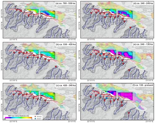
Landscapes are the integrated product of external forcings (e.g. tectonics and climate) and intrinsic characteristics (e.g. bedrock erodibility). In principle, hard bedrock with low erodibility can steepen rivers in a similar way to tectonic uplift. A key challenge in geomorphic analysis is thus separating the tectonic and lithological effects on landscapes. To address this, we focus on multiple rivers that are transiently incising through contrasting lithologies in the Gulf of Corinth, Greece, where tectonic history is broadly well constrained. We first exploit topographic metrics and river long profiles to demonstrate that landscapes are responding to both tectonics and lithology. In particular, the long profiles are divided into knickpoint‐bounded segments, and at this scale, channel steepness is shown to be more sensitive to lithology than the entire catchment, possibly due to relatively uniform erosion rate at the segment scale. We then use segment‐scale steepness variations between different lithologies to constrain their relative erodibilities (K lime :K cong. :K sand‐silt :K p‐con sed. = 1:2:3:4), which are further converted into actual lithology‐dependent erodibilities by modelling a well‐constrained, ca. 700 ka knickpoint in the Vouraikos catchment. The effectiveness of lithology‐dependent erodibilities is supported by the observation that if lithology‐dependent erodibilities are used to calibrate studied river long profiles in χ distance, we obtain long profile concavities that fall within the theoretical range. Finally, we use lithology‐calibrated metrics to provide new geomorphic constraints on the timing and magnitude of tectonic perturbations in these catchments. These geomorphic results are interpreted in conjunction with previous onshore and offshore studies to shed new light on fault growth and linkage history in the Gulf of Corinth. Our study therefore provides a topographic analysis‐based approach to quantify lithological effects on transient catchments, with important implications for tectonic interpretations of topographic metrics in lithologically heterogenous landscapes.
中文翻译:

揭示构造和岩性对希腊科林斯湾瞬态景观的影响
景观是外部强迫(例如构造和气候)和内在特征(例如基岩侵蚀性)的综合产物。原则上,具有低侵蚀性的坚硬基岩可以以与构造隆升类似的方式使河流变陡。因此,地貌分析的一个关键挑战是区分构造和岩性对景观的影响。为了解决这个问题,我们关注希腊科林斯湾的多条河流,这些河流短暂地切入对比鲜明的岩性,那里的构造历史基本上受到很好的限制。我们首先利用地形指标和河流长剖面来证明景观对构造和岩性都有反应。特别是,长剖面被分为以拐点为界的分段,在这个尺度上,河道陡度对岩性比整个流域更敏感,这可能是由于分段尺度上的侵蚀率相对均匀。然后,我们使用不同岩性之间的分段尺度陡度变化来限制它们的相对可蚀性(Klime:Kcong.:Ksand‐silt:Kp‐con sed. = 1:2:3:4),这些可进一步转换为实际的岩性依赖性通过对约束良好的模型进行侵蚀性,大约。 Vouraikos 流域的 700 ka 临界点。岩性相关的侵蚀性的有效性得到了观察的支持,即如果使用岩性相关的侵蚀性来校准研究的河流长剖面的 χ 距离,我们将获得落在理论范围内的长剖面凹度。最后,我们使用岩性校准指标为这些流域构造扰动的时间和幅度提供新的地貌约束。 这些地貌结果与之前的陆上和海上研究相结合进行解释,为科林斯湾断层生长和联系历史提供新的线索。因此,我们的研究提供了一种基于地形分析的方法来量化岩性对瞬态流域的影响,对岩性异质景观中地形指标的构造解释具有重要意义。
更新日期:2024-09-12
中文翻译:

揭示构造和岩性对希腊科林斯湾瞬态景观的影响
景观是外部强迫(例如构造和气候)和内在特征(例如基岩侵蚀性)的综合产物。原则上,具有低侵蚀性的坚硬基岩可以以与构造隆升类似的方式使河流变陡。因此,地貌分析的一个关键挑战是区分构造和岩性对景观的影响。为了解决这个问题,我们关注希腊科林斯湾的多条河流,这些河流短暂地切入对比鲜明的岩性,那里的构造历史基本上受到很好的限制。我们首先利用地形指标和河流长剖面来证明景观对构造和岩性都有反应。特别是,长剖面被分为以拐点为界的分段,在这个尺度上,河道陡度对岩性比整个流域更敏感,这可能是由于分段尺度上的侵蚀率相对均匀。然后,我们使用不同岩性之间的分段尺度陡度变化来限制它们的相对可蚀性(Klime:Kcong.:Ksand‐silt:Kp‐con sed. = 1:2:3:4),这些可进一步转换为实际的岩性依赖性通过对约束良好的模型进行侵蚀性,大约。 Vouraikos 流域的 700 ka 临界点。岩性相关的侵蚀性的有效性得到了观察的支持,即如果使用岩性相关的侵蚀性来校准研究的河流长剖面的 χ 距离,我们将获得落在理论范围内的长剖面凹度。最后,我们使用岩性校准指标为这些流域构造扰动的时间和幅度提供新的地貌约束。 这些地貌结果与之前的陆上和海上研究相结合进行解释,为科林斯湾断层生长和联系历史提供新的线索。因此,我们的研究提供了一种基于地形分析的方法来量化岩性对瞬态流域的影响,对岩性异质景观中地形指标的构造解释具有重要意义。


 京公网安备 11010802027423号