当前位置:
X-MOL 学术
›
Basin Res.
›
论文详情
Our official English website, www.x-mol.net, welcomes your
feedback! (Note: you will need to create a separate account there.)
Late Palaeozoic structural evolution of the Patch Bank Ridge and Utsira High, northern North Sea
Basin Research ( IF 2.8 ) Pub Date : 2024-08-31 , DOI: 10.1111/bre.12890 M. S. Bauck 1, 2 , J. I. Faleide 1 , H. Fossen 3 , M. Hassaan 1, 4 , A. Braathen 1
Basin Research ( IF 2.8 ) Pub Date : 2024-08-31 , DOI: 10.1111/bre.12890 M. S. Bauck 1, 2 , J. I. Faleide 1 , H. Fossen 3 , M. Hassaan 1, 4 , A. Braathen 1
Affiliation

|
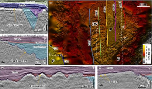
This study focuses on the Late Palaeozoic development of the area east of Utsira High in the North Sea, where the stratigraphic section below the late Permian Rotliegend Group is undrilled. We use regional 3D seismic data to study structuring, sediment distribution and geomorphology across the Patch Bank Ridge and Utsira High in the North Sea. The results show that the Stord Basin and the bounding Utsira East fault initially developed during the Late Palaeozoic extension, probably during the Devonian, and that the Utsira Shear Zone controlled the location of Late Palaeozoic depocentres. The Patch Bank Ridge is an uplifted part of the Stord Basin where we identify Late Palaeozoic growth strata along the southern and northern flanks, indicating a similar timing of the structural evolution in this area. Two key wells, in the Sele High and Ling Depression, are used to relate a Late Palaeozoic isopach map with regional structuring, surface tilt and basement morphology to the enigmatic parts of the Late Palaeozoic basin system. Our results supplement regional models for the Late Palaeozoic basin development, we suggest that the deeply eroded Devonian half‐grabens preserved on the Utsira High formed parts of an extensive basin system that show stratigraphic expansion towards their bounding faults. The Top Basement surface at these highs offers several distinct geomorphologies that evolved during three periods of exposure, expressed as (i) a tilted and rugose landscape, (ii) distinct drainage networks and (iii) peneplain surfaces. Cover sediments place these landscapes to the (i) Devonian, (ii) Carboniferous/Permian/Triassic and (iii) Late Triassic periods.
中文翻译:

北海北部 Patch Bank 海脊和 Utsira 高地的晚古生代结构演化
本研究重点关注北海乌齐拉高地以东地区的晚古生代发育,该地区晚二叠世 Rotliegend 群下方的地层剖面尚未钻探。我们使用区域 3D 地震数据来研究北海 Patch Bank Ridge 和 Utsira High 的结构、沉积物分布和地貌。结果表明,斯托德盆地和边界的乌齐拉东断层最初发育于晚古生代伸展期间,可能是在泥盆纪,而乌齐拉剪切带控制了晚古生代沉降中心的位置。 Patch Bank 山脊是 Stord 盆地的隆起部分,我们在此发现了沿南侧和北侧的晚古生代生长地层,表明该地区的构造演化时间相似。色勒高地和岭凹陷的两口关键井用于将晚古生代等厚线图与区域构造、地表倾斜和基底形态与晚古生代盆地系统的神秘部分联系起来。我们的研究结果补充了晚古生代盆地发育的区域模型,我们认为乌齐拉高地保留的深度侵蚀的泥盆纪半地堑形成了广阔盆地系统的一部分,显示出地层向其边界断层扩张。这些高点的地下室顶部表面提供了在三个暴露时期演变的几种不同的地貌,表现为(i)倾斜和皱纹的景观,(ii)独特的排水网络和(iii)准平原表面。覆盖沉积物将这些景观置于(i)泥盆纪,(ii)石炭纪/二叠纪/三叠纪和(iii)晚三叠世时期。
更新日期:2024-08-31
中文翻译:

北海北部 Patch Bank 海脊和 Utsira 高地的晚古生代结构演化
本研究重点关注北海乌齐拉高地以东地区的晚古生代发育,该地区晚二叠世 Rotliegend 群下方的地层剖面尚未钻探。我们使用区域 3D 地震数据来研究北海 Patch Bank Ridge 和 Utsira High 的结构、沉积物分布和地貌。结果表明,斯托德盆地和边界的乌齐拉东断层最初发育于晚古生代伸展期间,可能是在泥盆纪,而乌齐拉剪切带控制了晚古生代沉降中心的位置。 Patch Bank 山脊是 Stord 盆地的隆起部分,我们在此发现了沿南侧和北侧的晚古生代生长地层,表明该地区的构造演化时间相似。色勒高地和岭凹陷的两口关键井用于将晚古生代等厚线图与区域构造、地表倾斜和基底形态与晚古生代盆地系统的神秘部分联系起来。我们的研究结果补充了晚古生代盆地发育的区域模型,我们认为乌齐拉高地保留的深度侵蚀的泥盆纪半地堑形成了广阔盆地系统的一部分,显示出地层向其边界断层扩张。这些高点的地下室顶部表面提供了在三个暴露时期演变的几种不同的地貌,表现为(i)倾斜和皱纹的景观,(ii)独特的排水网络和(iii)准平原表面。覆盖沉积物将这些景观置于(i)泥盆纪,(ii)石炭纪/二叠纪/三叠纪和(iii)晚三叠世时期。


 京公网安备 11010802027423号