当前位置:
X-MOL 学术
›
Basin Res.
›
论文详情
Our official English website, www.x-mol.net, welcomes your
feedback! (Note: you will need to create a separate account there.)
Palaeogeography and 3D variability of a dynamically uplifted shelf: Observations from seismic stratigraphy of the Palaeocene East Shetland Platform
Basin Research ( IF 2.8 ) Pub Date : 2024-08-28 , DOI: 10.1111/bre.12895 Lucas Albanese Valore 1 , Tor Oftedal Sømme 1, 2 , Stefano Patruno 3 , Cécile Robin 4 , François Guillocheau 4 , Christian Haug Eide 1
Basin Research ( IF 2.8 ) Pub Date : 2024-08-28 , DOI: 10.1111/bre.12895 Lucas Albanese Valore 1 , Tor Oftedal Sømme 1, 2 , Stefano Patruno 3 , Cécile Robin 4 , François Guillocheau 4 , Christian Haug Eide 1
Affiliation

|
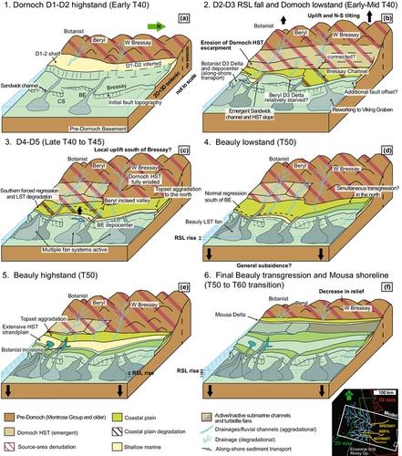
In the Palaeocene North Sea, pulses in turbidite fan deposition and shelfal progradation have been correlated with episodes of regional uplift caused by a precursor of the Icelandic Plume. In the East Shetland Platform, the specific impacts of dynamic uplift on the regional palaeogeographic evolution are less understood. Using new, high‐resolution 3D seismic data from an underexplored proximal area, we investigate the palaeogeography of the East Shetland Platform in terms of the extent and timing of erosion versus deposition, focusing on how these can be used to reconstruct changes in relative sea‐level along strike. Using a combination of well data, clinoform‐based seismic stratigraphy and seismic attribute analysis of >60,000 km2 of 3D data, we have obtained palaeogeographic maps of multiple Palaeocene to Early Eocene units, with high temporal resolution for the Late Palaeocene–Early Eocene Moray Group. This includes six unconformity‐bounded units marked by prograding clinoforms of the Dornoch Formation, which are covered by backstepping sequences of the Beauly Member (Balder Formation). Temporal and spatial changes in the distribution of downdip depocentres and updip unconformities indicate strong lateral variability in patterns of shelf accommodation/erosion and local sediment supply. This results from a complex interplay among laterally uneven relative sea‐level fall, inherited topography, time‐varied sediment entry point distribution and along‐shore sediment transport regimes. Unconformities and palaeogeographic maps suggest a first‐order control on erosion and sediment distribution promoted by the transiently and differentially uplifted topography of Shetland, which is characterized by an anomalous erosive history in the Bressay High, in the centre of our study area, where the Lower Dornoch Formation has been eroded and marked fluvial incision is observed. Ultimately, results indicate shorter‐wavelength and shorter‐period variations in uplift than what is typically assumed for dynamic topography, perhaps as a result of additional modulation by lithospheric structures or influence of previous rift‐related faults.
中文翻译:

动态隆起陆架的古地理和 3D 变化:古新世东设得兰地台地震地层学观测
在古新世北海,浊积扇沉积和陆架进积的脉冲与冰岛羽流前体引起的区域隆起事件相关。在东设得兰地台,动态隆升对区域古地理演化的具体影响知之甚少。使用来自未勘探的近端区域的新的高分辨率 3D 地震数据,我们从侵蚀与沉积的范围和时间方面研究了东设得兰台地的古地理,重点是如何利用这些数据来重建相对海平面的变化。沿罢工水平。结合井数据、基于斜面的地震地层学和>60,000 km2 3D数据的地震属性分析,我们获得了多个古新世至早始新世单元的古地理图,其中晚古新世-早始新世具有高时间分辨率马里集团。这包括六个以 Dornoch 组的进积斜面为标志的不整合面边界单元,这些单元被 Beauly 段(Balder 组)的后退序列所覆盖。下倾沉降中心和上倾不整合面分布的时间和空间变化表明陆架容纳/侵蚀和当地沉积物供应模式存在强烈的横向变化。这是由于横向不均匀的相对海平面下降、继承的地形、随时间变化的沉积物进入点分布和沿岸沉积物输送机制之间复杂的相互作用造成的。 不整合面和古地理图表明,设得兰群岛的短暂和差异性抬升地形促进了对侵蚀和沉积物分布的一级控制,其特点是布雷赛高地的异常侵蚀历史,该高地位于我们研究区的中心, Dornoch 地层已被侵蚀,观察到明显的河流切口。最终,结果表明,与动态地形通常假设的情况相比,隆起的波长和周期变化更短,这可能是由于岩石圈结构的额外调制或先前与裂谷相关的断层的影响所致。
更新日期:2024-08-28
中文翻译:

动态隆起陆架的古地理和 3D 变化:古新世东设得兰地台地震地层学观测
在古新世北海,浊积扇沉积和陆架进积的脉冲与冰岛羽流前体引起的区域隆起事件相关。在东设得兰地台,动态隆升对区域古地理演化的具体影响知之甚少。使用来自未勘探的近端区域的新的高分辨率 3D 地震数据,我们从侵蚀与沉积的范围和时间方面研究了东设得兰台地的古地理,重点是如何利用这些数据来重建相对海平面的变化。沿罢工水平。结合井数据、基于斜面的地震地层学和>60,000 km2 3D数据的地震属性分析,我们获得了多个古新世至早始新世单元的古地理图,其中晚古新世-早始新世具有高时间分辨率马里集团。这包括六个以 Dornoch 组的进积斜面为标志的不整合面边界单元,这些单元被 Beauly 段(Balder 组)的后退序列所覆盖。下倾沉降中心和上倾不整合面分布的时间和空间变化表明陆架容纳/侵蚀和当地沉积物供应模式存在强烈的横向变化。这是由于横向不均匀的相对海平面下降、继承的地形、随时间变化的沉积物进入点分布和沿岸沉积物输送机制之间复杂的相互作用造成的。 不整合面和古地理图表明,设得兰群岛的短暂和差异性抬升地形促进了对侵蚀和沉积物分布的一级控制,其特点是布雷赛高地的异常侵蚀历史,该高地位于我们研究区的中心, Dornoch 地层已被侵蚀,观察到明显的河流切口。最终,结果表明,与动态地形通常假设的情况相比,隆起的波长和周期变化更短,这可能是由于岩石圈结构的额外调制或先前与裂谷相关的断层的影响所致。


 京公网安备 11010802027423号