Nature Geoscience ( IF 15.7 ) Pub Date : 2024-08-05 , DOI: 10.1038/s41561-024-01497-z Alexandre Normandeau , Jordan B. R. Eamer , Robert G. Way , Emma J. Harrison , Frédéric Cyr , Christopher K. Algar , Jennifer L. Eamer , Haley D. Geizer , Jessica Haddock , Barret L. Kurylyk , Nicolas Van Nieuwenhove , Liz Pijogge , Geneviève Philibert , Katleen Robert , Michelle Saunders , Joseph Tamborski , Audrey Limoges
|
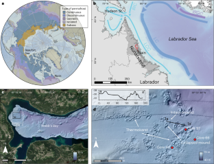
The distribution and state of subsea permafrost is largely unknown. Present maps, which rely heavily on model results, suggest that subsea permafrost is confined to the Beaufort, Siberian and Laptev seas. Here we show that discontinuous subsea permafrost exists along the Labrador coast (56 °N) under the influence of the Labrador Coastal Current. High-resolution bathymetric data reveal the presence of subsea thermokarst environments on the coastal seabed of Nain, Nunatsiavut, where an ice-rich sediment sample was recovered in July 2022 at a water depth of 27 m. Porewater analysis indicates that ground ice can persist in the sediments due to freshened submarine groundwater seepage that freezes at higher temperatures (0 °C) than seawater (−1.8 °C). The formation and preservation of subsea permafrost landforms is due to cold waters of the Labrador Coastal Current entering the coastal areas and remaining less than 0 °C for most of the year. Therefore, evidence of subsea permafrost landforms in coastal Labrador and the distribution of cold bottom water in the Northern Hemisphere suggests that subsea permafrost is likely to be preserved elsewhere in subarctic regions, especially where freshened submarine groundwater seepage elevates the freezing temperature. This highlights the potential underestimation of subsea permafrost in the world’s coastal oceans.
中文翻译:
加拿大亚北极地区海底永久冻土层与海底地下水排放有关的证据
海底永久冻土的分布和状态很大程度上未知。目前的地图在很大程度上依赖于模型结果,表明海底永久冻土仅限于波弗特海、西伯利亚海和拉普捷夫海。在这里,我们表明,在拉布拉多海岸流的影响下,拉布拉多海岸(北纬56°)存在不连续的海底永久冻土。高分辨率测深数据揭示了努纳齐亚武特地区纳因沿海海底存在海底热岩溶环境,2022 年 7 月在水深 27 m 处发现了富含冰的沉积物样本。孔隙水分析表明,由于新鲜的海底地下水渗流在比海水(−1.8 °C)更高的温度(0 °C)下结冰,地面冰可以持续存在于沉积物中。海底多年冻土地貌的形成和保存是由于拉布拉多沿岸流的冷水进入沿海地区并在一年中的大部分时间保持在0°C以下。因此,拉布拉多沿海海底永久冻土地貌和北半球冷底水分布的证据表明,亚北极地区其他地方可能保存有海底永久冻土,特别是在新鲜的海底地下水渗漏升高冰点温度的地方。这凸显了世界沿海海洋海底永久冻土层的潜在低估。


 京公网安备 11010802027423号