当前位置:
X-MOL 学术
›
Basin Res.
›
论文详情
Our official English website, www.x-mol.net, welcomes your
feedback! (Note: you will need to create a separate account there.)
Tectono‐sedimentary evolution of high‐displacement crustal‐scale normal faults and basement highs on rifted margins: Klakk Fault Complex and Frøya High, Mid‐Norwegian Margin
Basin Research ( IF 2.8 ) Pub Date : 2024-07-26 , DOI: 10.1111/bre.12889 Jhon M. Muñoz‐Barrera 1 , Rob Gawthorpe 1 , Tim Cullen 1 , Sofia Pechlivanidou 1 , Gijs Henstra 1 , Atle Rotevatn 1 , Ian Sharp 1, 2
Basin Research ( IF 2.8 ) Pub Date : 2024-07-26 , DOI: 10.1111/bre.12889 Jhon M. Muñoz‐Barrera 1 , Rob Gawthorpe 1 , Tim Cullen 1 , Sofia Pechlivanidou 1 , Gijs Henstra 1 , Atle Rotevatn 1 , Ian Sharp 1, 2
Affiliation

|
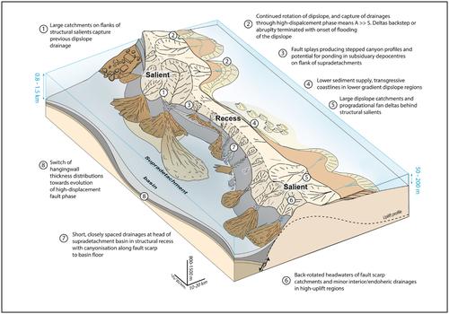
Crustal‐scale high‐displacement (>10 km) normal faults are not captured in existing tectono‐sedimentary models of rift basins. We used 2D and 3D seismic reflection and well data to perform a structural and source‐to‐sink analysis of the southern part of the Klakk Fault Complex and the western part of the Vingleia Fault Complex, Mid‐Norwegian rifted margin. The north–south trending Klakk Fault Complex has a zig‐zag to sinuous plan‐view geometry, forming a series of structural recesses and salients along strike. In cross‐section, the fault complex has a listric to convex‐up or low‐angle planar geometry with displacements above 20 km. This fault complex exhumed basement highs, the Frøya High and Sklinna Ridge, in its footwall and created a series of supradetachment basins, for example, the Rås Basin, in its hanging wall. In contrast, the northeast‐southwest trending Vingleia Fault Complex has a zig‐zag geometry in plan view and planar to listric geometry in cross‐section and displacement of up to 5 km. This fault has the Frøya High in its footwall and the southern Halten Terrace in its hanging wall. Restoration of selected structural cross‐sections shows a prominent fault‐parallel ridge, up to 15 km east of the Klakk Fault Complex interpreted as a palaeodrainage divide. This divide separates steep drainages developed along the west‐dipping footwall scarp to the Klakk Fault Complex, from broader, gentler east‐dipping drainages up to ca. 10 km long developed on a back‐tilted dip slopes along the eastern side of the Frøya High and Sklinna Ridge. Progressive headward erosion of active flank catchments was enhanced around topographically elevated structural salients to the point of capturing previous dip‐slope‐directed drainages during the earliest Cretaceous. A network of submarine canyons develop down‐dip of the drainage catchments along the Klakk Fault Complex scarp, whose geometries and length are controlled by their location with respect to the structural salients or recesses, and the presence of fault terraces. The middle Jurassic‐earliest Cretaceous synrift deposits form two seismic sequences that are filled with five distinctive seismic facies that record the evolution from a linked normal fault during rift climax to a high‐displacement stage. During the high displacement stage, exhumed local continental core complexes formed structural salients, separated along strike by structural recesses at the heads of supradetachment basins. Key elements of the high‐displacement fault stage include (i) the development of structural salients at sites of rift climax displacement maxima, (ii) development of supradetachment basins in rift climax displacement minima and (iii) migration of major depocentres away from the centre of rift climax fault segments. We synthesise these observations into a generic tectono‐sedimentary model for high‐displacement faults.
中文翻译:

高位移地壳规模正断层和裂谷边缘基底高点的构造沉积演化:Klakk 断层复合体和 Frøya 高地、挪威中缘
现有的裂谷盆地构造沉积模型中没有捕获地壳规模的高位移(>10公里)正断层。我们使用 2D 和 3D 地震反射和井数据对挪威中部裂谷边缘的 Klakk 断层复合体南部和 Vingleia 断层复合体西部进行了结构和源汇分析。南北走向的克拉克断层复合体具有锯齿状的蜿蜒平面几何形状,沿走向形成一系列结构凹陷和凸起。在横截面中,断层复合体具有列表状至上凸或小角度的平面几何形状,位移超过 20 公里。该断层复合体在其下盘挖出了基底高点、Frøya 高点和 Sklinna 山脊,并在其上盘形成了一系列超拆离盆地,例如 Rås 盆地。相比之下,东北-西南走向的 Vingleia 断层复合体在平面图中具有锯齿形几何形状,在横截面中具有平面至列表几何形状,位移高达 5 公里。该断层的下盘有Frøya High,上盘有南部的Halten Terrace。所选结构横截面的恢复显示了一个突出的断层平行山脊,位于克拉克断层复合体以东 15 公里处,被解释为古排水分水岭。这一分水岭将沿西倾下盘陡坡发展到克拉克断层复合体的陡峭水系与更宽、更平缓的东倾水系分开。 10 公里长,发育在沿着 Frøya High 和 Sklinna Ridge 东侧的后倾斜坡上。活动的侧翼流域的渐进性侵蚀在地形上升高的构造突出物周围得到增强,达到了最早白垩纪期间先前的倾角定向排水的程度。 海底峡谷网络沿着克拉克断层复合体陡坡发展出下倾的排水集水区,其几何形状和长度受其相对于结构突出物或凹陷的位置以及断层阶地的存在控制。中侏罗世-最早的白垩纪同裂谷沉积物形成两个地震序列,其中充满了五个独特的地震相,记录了从裂谷高潮期间的相连正断层到高位移阶段的演化。在高位移阶段,挖出的局部大陆核心杂岩形成构造凸起,沿走向被超滑脱盆地顶部的构造凹陷分开。高位移断层阶段的关键要素包括(i)在裂谷顶峰位移最大值处发育构造凸起,(ii)在裂谷顶峰位移最小值处超滑脱盆地发育,以及(iii)主要沉积中心远离中心的迁移裂谷顶断层段。我们将这些观测结果综合成一个高位移断层的通用构造沉积模型。
更新日期:2024-07-26
中文翻译:

高位移地壳规模正断层和裂谷边缘基底高点的构造沉积演化:Klakk 断层复合体和 Frøya 高地、挪威中缘
现有的裂谷盆地构造沉积模型中没有捕获地壳规模的高位移(>10公里)正断层。我们使用 2D 和 3D 地震反射和井数据对挪威中部裂谷边缘的 Klakk 断层复合体南部和 Vingleia 断层复合体西部进行了结构和源汇分析。南北走向的克拉克断层复合体具有锯齿状的蜿蜒平面几何形状,沿走向形成一系列结构凹陷和凸起。在横截面中,断层复合体具有列表状至上凸或小角度的平面几何形状,位移超过 20 公里。该断层复合体在其下盘挖出了基底高点、Frøya 高点和 Sklinna 山脊,并在其上盘形成了一系列超拆离盆地,例如 Rås 盆地。相比之下,东北-西南走向的 Vingleia 断层复合体在平面图中具有锯齿形几何形状,在横截面中具有平面至列表几何形状,位移高达 5 公里。该断层的下盘有Frøya High,上盘有南部的Halten Terrace。所选结构横截面的恢复显示了一个突出的断层平行山脊,位于克拉克断层复合体以东 15 公里处,被解释为古排水分水岭。这一分水岭将沿西倾下盘陡坡发展到克拉克断层复合体的陡峭水系与更宽、更平缓的东倾水系分开。 10 公里长,发育在沿着 Frøya High 和 Sklinna Ridge 东侧的后倾斜坡上。活动的侧翼流域的渐进性侵蚀在地形上升高的构造突出物周围得到增强,达到了最早白垩纪期间先前的倾角定向排水的程度。 海底峡谷网络沿着克拉克断层复合体陡坡发展出下倾的排水集水区,其几何形状和长度受其相对于结构突出物或凹陷的位置以及断层阶地的存在控制。中侏罗世-最早的白垩纪同裂谷沉积物形成两个地震序列,其中充满了五个独特的地震相,记录了从裂谷高潮期间的相连正断层到高位移阶段的演化。在高位移阶段,挖出的局部大陆核心杂岩形成构造凸起,沿走向被超滑脱盆地顶部的构造凹陷分开。高位移断层阶段的关键要素包括(i)在裂谷顶峰位移最大值处发育构造凸起,(ii)在裂谷顶峰位移最小值处超滑脱盆地发育,以及(iii)主要沉积中心远离中心的迁移裂谷顶断层段。我们将这些观测结果综合成一个高位移断层的通用构造沉积模型。


 京公网安备 11010802027423号