当前位置:
X-MOL 学术
›
Basin Res.
›
论文详情
Our official English website, www.x-mol.net, welcomes your
feedback! (Note: you will need to create a separate account there.)
New insights into the structural and stratigraphic evolution of the Malay Basin using 3D seismic data: Implications for regional carbon capture and storage potential
Basin Research ( IF 2.8 ) Pub Date : 2024-07-08 , DOI: 10.1111/bre.12885 Iain de Jonge‐Anderson 1 , Ana Widyanita 1, 2 , Andreas Busch 3 , Florian Doster 1 , Uisdean Nicholson 1
Basin Research ( IF 2.8 ) Pub Date : 2024-07-08 , DOI: 10.1111/bre.12885 Iain de Jonge‐Anderson 1 , Ana Widyanita 1, 2 , Andreas Busch 3 , Florian Doster 1 , Uisdean Nicholson 1
Affiliation

|
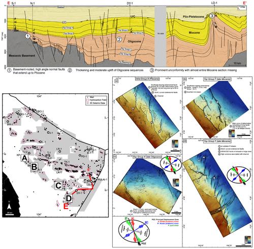
The Malay Basin is a mature hydrocarbon province currently being re‐assessed for CO2 storage. Selecting an appropriate storage site requires a comprehensive understanding of the structural and stratigraphic history of the basin. However, previous studies have been limited to observations from either regional 2D seismic lines or individual 3D seismic volumes. In this study, we access and utilise a basin‐wide (ca. 36,000 km2 ) 3D seismic and well database to describe the structural and stratigraphic features of the basin, particularly those within the uppermost ca. 4 km (Oligocene to Recent) and gain new insights into the basin's evolution. E–W transtensional rift basins first developed due to sinistral shear across an NW‐SE strike‐slip zone. The NW‐SE basin morphology seen today was generated during the late Oligocene–early Miocene, during which time dextral motion across marginal hinge zones created en‐echelon antithetic, extensional faults and pull‐apart basins, especially well preserved along the western margin of the basin. Collisional forces to the southeast during the early to middle Miocene resulted in the shallowing of the basin, intermittent connection to the South China Sea and a cyclic depositional pattern. Around 8 Ma (late Miocene), a significant uplift of the basin resulted in a major unconformity with up to 4.2 km of erosion and exhumation in the southeast. In the centre and northwest of the basin, the inversion of deeper E–W rifts resulted in the folding of Miocene sequences and the formation of large anticlines parallel to the rift‐bounding faults. The Pliocene to Pleistocene history is more tectonically quiescent, but some extensional faulting continued to affect the northwest part of the basin. Larger glacio‐eustatic sea‐level fluctuations during this time resulted in major changes in sedimentation and erosion on the Sunda Shelf, including the formation of a middle‐Pliocene unconformity. These structural events have created a variety of hydrocarbon traps across the basin of different ages, including transpressional anticlines, rollover anticlines and tilted fault blocks. Each of these has discrete and distinct trap elements with important implications for their CO2 storage potential.
中文翻译:

使用 3D 地震数据对马来盆地的结构和地层演化的新见解:对区域碳捕获和储存潜力的影响
马来盆地是一个成熟的碳氢化合物省,目前正在重新评估二氧化碳储存量。选择合适的封存地点需要全面了解盆地的结构和地层历史。然而,之前的研究仅限于区域 2D 地震线或单个 3D 地震体的观测。在本研究中,我们访问并利用全盆地(约 36,000 平方公里)3D 地震和井数据库来描述盆地的结构和地层特征,特别是最上面约 36,000 平方公里的盆地结构和地层特征。 4 公里(渐新世到近代)并获得有关盆地演化的新见解。东西向拉张裂谷盆地最初是由于横跨西北-东南走向滑移带的左旋剪切而形成的。今天看到的西北-东南盆地形态形成于渐新世晚期至中新世早期,在此期间,跨越边缘铰接带的右旋运动形成了梯队对立、伸展断层和拉断盆地,尤其是沿盆地西缘保存完好。盆地。中新世早至中新世期间向东南方向的碰撞力导致盆地变浅,与南海间歇性相连,形成旋回沉积模式。大约8Ma(中新世晚期),盆地显着隆升,导致东南部出现长达4.2公里的严重不整合面侵蚀和折返。在盆地中部和西北部,更深的东西向裂谷的反转导致了中新世层序的褶皱和平行于裂谷边界断层的大型背斜的形成。上新世至更新世的历史在构造上较为静止,但一些伸展断层继续影响着盆地的西北部。 在此期间,较大的冰川海平面波动导致巽他陆架的沉积和侵蚀发生重大变化,包括形成中上新世不整合面。这些构造事件在盆地不同年代形成了多种油气圈闭,包括压扭背斜、翻转背斜和倾斜断块。每一个都具有离散且独特的捕集元件,对其二氧化碳储存潜力具有重要影响。
更新日期:2024-07-08
中文翻译:

使用 3D 地震数据对马来盆地的结构和地层演化的新见解:对区域碳捕获和储存潜力的影响
马来盆地是一个成熟的碳氢化合物省,目前正在重新评估二氧化碳储存量。选择合适的封存地点需要全面了解盆地的结构和地层历史。然而,之前的研究仅限于区域 2D 地震线或单个 3D 地震体的观测。在本研究中,我们访问并利用全盆地(约 36,000 平方公里)3D 地震和井数据库来描述盆地的结构和地层特征,特别是最上面约 36,000 平方公里的盆地结构和地层特征。 4 公里(渐新世到近代)并获得有关盆地演化的新见解。东西向拉张裂谷盆地最初是由于横跨西北-东南走向滑移带的左旋剪切而形成的。今天看到的西北-东南盆地形态形成于渐新世晚期至中新世早期,在此期间,跨越边缘铰接带的右旋运动形成了梯队对立、伸展断层和拉断盆地,尤其是沿盆地西缘保存完好。盆地。中新世早至中新世期间向东南方向的碰撞力导致盆地变浅,与南海间歇性相连,形成旋回沉积模式。大约8Ma(中新世晚期),盆地显着隆升,导致东南部出现长达4.2公里的严重不整合面侵蚀和折返。在盆地中部和西北部,更深的东西向裂谷的反转导致了中新世层序的褶皱和平行于裂谷边界断层的大型背斜的形成。上新世至更新世的历史在构造上较为静止,但一些伸展断层继续影响着盆地的西北部。 在此期间,较大的冰川海平面波动导致巽他陆架的沉积和侵蚀发生重大变化,包括形成中上新世不整合面。这些构造事件在盆地不同年代形成了多种油气圈闭,包括压扭背斜、翻转背斜和倾斜断块。每一个都具有离散且独特的捕集元件,对其二氧化碳储存潜力具有重要影响。


 京公网安备 11010802027423号