当前位置:
X-MOL 学术
›
J. Hydrol.
›
论文详情
Our official English website, www.x-mol.net, welcomes your
feedback! (Note: you will need to create a separate account there.)
Hydrologic responses to wildfires in western Oregon, USA
Journal of Hydrology ( IF 5.9 ) Pub Date : 2024-07-02 , DOI: 10.1016/j.jhydrol.2024.131612 Hyunwoo Kang , Ryan P. Cole , Lorrayne Miralha , Jana E. Compton , Kevin D. Bladon
Journal of Hydrology ( IF 5.9 ) Pub Date : 2024-07-02 , DOI: 10.1016/j.jhydrol.2024.131612 Hyunwoo Kang , Ryan P. Cole , Lorrayne Miralha , Jana E. Compton , Kevin D. Bladon

|
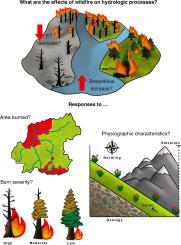
Wildfires can dramatically alter vegetation cover and soil properties across large scales, resulting in substantial shifts in runoff generation, streamflow, and water quality. In September 2020, extensive and high-severity wildfires burned more than 490,000 ha of forest land on the westside of the Cascade Mountain Range in the Pacific Northwest. Much of the area impacted by these fires is critical for the provision of water for downstream aquatic ecosystems, agriculture, hydropower, recreation, and municipal drinking water. We undertook a study to evaluate the effects of four of the large high severity wildfires from 2020 (Riverside, Beachie Creek, Lionshead, and Holiday Farm) on streamflow in nine burned catchments in western Oregon. We also included four unburned, reference catchments in our analysis to enable us to assess post-fire streamflow changes in the burned catchments. To quantify the effects of wildfire on the catchment water balance we used publicly available streamflow data and estimated precipitation, potential evapotranspiration (PET), and actual evapotranspiration (ET), using satellite-based meteorological data. We quantified catchment area burned and burn severity with the average differenced normalized burn ratio (dNBR). We compared hydrologic conditions for the pre-fire (2001–2020) and post-fire (2021–2022) periods by analyzing catchment runoff ratios, ET ratios (evaporative index: quotient of ET divided by precipitation, referred to as EI hereafter), and Budyko curves. We also used random forest models to explore factors influencing the variability in EI. During the post-fire period, we observed decreases in EI and increases in runoff ratio in the burned catchments. Post-fire declines in EI were positively related to burn severity (R 2 = 0.70 in 2021; 0.76 in 2022) and area burned (R 2 = 0.91 in 2021; 0.95 in 2022), and were primarily driven by decreases in ET. Declines in ET were highly variable, ranging from 10.7–40.2 % in the first year after the fires and 6.1–32.0 % in the second year after the fires, and were generally related to catchment burn severity and area burned. The greatest increases in runoff (16.1 % in 2021 and 19.8 % in 2022) occurred in the same catchment. These results were reinforced by the random forest analysis, which illustrated the importance of burn severity as a predictor of EI. Interestingly, the variability in changes in EI during the post-fire period was also associated with other geomorphic factors such as catchment slope, elevation, geology, aspect, and pre-fire vegetation type. Since the duration and seasonality of post-fire impacts on hydrology remain uncertain, our findings bring new insights and guide future studies into the post-fire responses on hydrology that are crucial for water and forest management.
中文翻译:

美国俄勒冈州西部野火的水文响应
野火可以极大地改变大尺度的植被覆盖和土壤特性,从而导致径流产生、径流和水质发生重大变化。2020 年 9 月,太平洋西北部喀斯喀特山脉西侧大面积和严重的野火烧毁了超过 490,000 公顷的林地。受这些火灾影响的大部分地区对于为下游水生生态系统、农业、水电、娱乐和城市饮用水提供水至关重要。我们进行了一项研究,以评估 2020 年发生的四场大型严重野火(Riverside、Beachie Creek、Lionshead 和 Holiday Farm)对俄勒冈州西部 9 个被烧毁集水区的溪流的影响。我们还在分析中包括了四个未燃烧的参考集水区,以使我们能够评估被烧毁集水区火灾后的径流变化。为了量化野火对集水区水平衡的影响,我们使用了公开可用的径流数据,并使用基于卫星的气象数据估计降水量、潜在蒸散量 (PET) 和实际蒸散量 (ET)。我们使用平均差异标准化燃烧比 (dNBR) 量化了燃烧的集水区面积和燃烧严重程度。我们通过分析流域径流比率、ET 比率(蒸发指数:ET 除以降水的商,以下简称 EI)和 Budyko 曲线,比较了火灾前 (2001-2020) 和火灾后 (2021-2022) 时期的水文条件。我们还使用随机森林模型来探索影响 EI 变异性的因素。在火灾后期间,我们观察到被烧毁集水区的 EI 降低和径流比率增加。火灾后 EI 的下降与烧伤严重程度呈正相关 (R2 = 0.2021 年为 70 人;2022 年为 0.76)和燃烧面积(2021 年 R2 = 0.91;2022 年为 0.95),主要是由 ET 的减少驱动的。ET 的下降幅度很大,火灾后第一年的下降幅度为 10.7-40.2%,火灾后第二年的下降幅度为 6.1-32.0%,通常与集水区燃烧的严重程度和燃烧面积有关。径流增幅最大(2021 年为 16.1%,2022 年为 19.8%)发生在同一个集水区。随机森林分析强化了这些结果,该分析说明了烧伤严重程度作为 EI 预测因子的重要性。有趣的是,火灾后 EI 变化的可变性也与其他地貌因素有关,例如集水区坡度、高程、地质、坡向和火灾前植被类型。由于火灾后对水文影响的持续时间和季节性仍不确定,我们的研究结果为火灾后对水文的反应提供了新的见解,并指导未来的研究,这些反应对水和森林管理至关重要。
更新日期:2024-07-02
中文翻译:

美国俄勒冈州西部野火的水文响应
野火可以极大地改变大尺度的植被覆盖和土壤特性,从而导致径流产生、径流和水质发生重大变化。2020 年 9 月,太平洋西北部喀斯喀特山脉西侧大面积和严重的野火烧毁了超过 490,000 公顷的林地。受这些火灾影响的大部分地区对于为下游水生生态系统、农业、水电、娱乐和城市饮用水提供水至关重要。我们进行了一项研究,以评估 2020 年发生的四场大型严重野火(Riverside、Beachie Creek、Lionshead 和 Holiday Farm)对俄勒冈州西部 9 个被烧毁集水区的溪流的影响。我们还在分析中包括了四个未燃烧的参考集水区,以使我们能够评估被烧毁集水区火灾后的径流变化。为了量化野火对集水区水平衡的影响,我们使用了公开可用的径流数据,并使用基于卫星的气象数据估计降水量、潜在蒸散量 (PET) 和实际蒸散量 (ET)。我们使用平均差异标准化燃烧比 (dNBR) 量化了燃烧的集水区面积和燃烧严重程度。我们通过分析流域径流比率、ET 比率(蒸发指数:ET 除以降水的商,以下简称 EI)和 Budyko 曲线,比较了火灾前 (2001-2020) 和火灾后 (2021-2022) 时期的水文条件。我们还使用随机森林模型来探索影响 EI 变异性的因素。在火灾后期间,我们观察到被烧毁集水区的 EI 降低和径流比率增加。火灾后 EI 的下降与烧伤严重程度呈正相关 (R2 = 0.2021 年为 70 人;2022 年为 0.76)和燃烧面积(2021 年 R2 = 0.91;2022 年为 0.95),主要是由 ET 的减少驱动的。ET 的下降幅度很大,火灾后第一年的下降幅度为 10.7-40.2%,火灾后第二年的下降幅度为 6.1-32.0%,通常与集水区燃烧的严重程度和燃烧面积有关。径流增幅最大(2021 年为 16.1%,2022 年为 19.8%)发生在同一个集水区。随机森林分析强化了这些结果,该分析说明了烧伤严重程度作为 EI 预测因子的重要性。有趣的是,火灾后 EI 变化的可变性也与其他地貌因素有关,例如集水区坡度、高程、地质、坡向和火灾前植被类型。由于火灾后对水文影响的持续时间和季节性仍不确定,我们的研究结果为火灾后对水文的反应提供了新的见解,并指导未来的研究,这些反应对水和森林管理至关重要。


 京公网安备 11010802027423号