当前位置:
X-MOL 学术
›
J. Hydrol.
›
论文详情
Our official English website, www.x-mol.net, welcomes your feedback! (Note: you will need to create a separate account there.)
Multi-objective optimisation framework for Blue-Green Infrastructure placement using detailed flood model
Journal of Hydrology ( IF 5.9 ) Pub Date : 2024-06-22 , DOI: 10.1016/j.jhydrol.2024.131571 Asid Ur Rehman , Vassilis Glenis , Elizabeth Lewis , Chris Kilsby
Journal of Hydrology ( IF 5.9 ) Pub Date : 2024-06-22 , DOI: 10.1016/j.jhydrol.2024.131571 Asid Ur Rehman , Vassilis Glenis , Elizabeth Lewis , Chris Kilsby
|
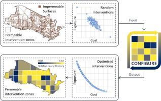
Designing city-scale Blue-Green Infrastructure (BGI) for flood risk management requires detailed and robust methods. This is due to the complex interaction of flow pathways and the need to assess cost-benefit trade-offs for various BGI options. This study aims to find a cost-effective BGI placement scheme by developing an improved approach called the Cost OptimisatioN Framework for Implementing blue-Green infrastructURE (CONFIGURE). The optimisation framework integrates a detailed hydrodynamic flood simulation model with a multi-objective optimisation algorithm (Non-dominated Sorting Genetic Algorithm II). The use of a high-resolution flood simulation model ensures the explicit representation of BGI and other land use features to simulate flow pathways and surface flood risk accurately, while the optimisation algorithm guarantees achieving the best cost-benefit trade-offs for given BGI options. The current study uses the advanced CityCAT hydrodynamic flood model to evaluate the efficiency of the optimisation framework and the impact of location and size of permeable interventions on the optimisation process and subsequent cost-benefit trade-offs. This is achieved by dividing permeable surface areas into intervention zones of varying size and quantity. Furthermore, rainstorm events with 100-year and 30-year return periods are analysed to identify any common optimal solutions for different rainfall intensities. Depending on the number of intervention locations, the automated framework reliably achieves optimal BGI implementation solutions in a fraction of the time required to find the best solutions by trialling all possible options. Designing and optimising interventions with smaller sizes but many permeable zones save a good fraction of investment. However, such a design scheme requires more computational time to find optimal options. Furthermore, the optimal spatial configuration of BGI varies with different rainstorm severities, suggesting a need for careful selection of the rainstorm return period. Based on the results, CONFIGURE shows promise in devising sustainable urban flood risk management designs.
中文翻译:

使用详细洪水模型的蓝绿基础设施布局的多目标优化框架
设计用于洪水风险管理的城市规模蓝绿基础设施 (BGI) 需要详细而稳健的方法。这是由于流动路径的复杂相互作用以及需要评估各种华大基因选项的成本效益权衡。本研究旨在通过开发一种称为“实施蓝绿基础设施成本优化框架”(CONFIGURE)的改进方法,找到一种具有成本效益的 BGI 布局方案。该优化框架集成了详细的水动力洪水模拟模型和多目标优化算法(非支配排序遗传算法 II)。高分辨率洪水模拟模型的使用确保了 BGI 和其他土地利用特征的明确表示,以准确模拟水流路径和地表洪水风险,而优化算法则保证了给定 BGI 选项实现最佳成本效益权衡。当前的研究使用先进的 CityCAT 水动力洪水模型来评估优化框架的效率以及渗透性干预措施的位置和规模对优化过程和后续成本效益权衡的影响。这是通过将可渗透表面区域划分为不同大小和数量的干预区域来实现的。此外,还分析了100年和30年一遇的暴雨事件,以确定针对不同降雨强度的常见最优解决方案。根据干预地点的数量,自动化框架可以通过尝试所有可能的选项,在找到最佳解决方案所需的一小部分时间内可靠地实现最佳 BGI 实施解决方案。设计和优化规模较小但渗透区域较多的干预措施可以节省很大一部分投资。 然而,这样的设计方案需要更多的计算时间来找到最佳选项。此外,BGI的最佳空间配置随暴雨强度的不同而变化,需要谨慎选择暴雨重现期。根据结果,CONFIGURE 在设计可持续城市洪水风险管理设计方面显示出前景。
更新日期:2024-06-22
中文翻译:
使用详细洪水模型的蓝绿基础设施布局的多目标优化框架
设计用于洪水风险管理的城市规模蓝绿基础设施 (BGI) 需要详细而稳健的方法。这是由于流动路径的复杂相互作用以及需要评估各种华大基因选项的成本效益权衡。本研究旨在通过开发一种称为“实施蓝绿基础设施成本优化框架”(CONFIGURE)的改进方法,找到一种具有成本效益的 BGI 布局方案。该优化框架集成了详细的水动力洪水模拟模型和多目标优化算法(非支配排序遗传算法 II)。高分辨率洪水模拟模型的使用确保了 BGI 和其他土地利用特征的明确表示,以准确模拟水流路径和地表洪水风险,而优化算法则保证了给定 BGI 选项实现最佳成本效益权衡。当前的研究使用先进的 CityCAT 水动力洪水模型来评估优化框架的效率以及渗透性干预措施的位置和规模对优化过程和后续成本效益权衡的影响。这是通过将可渗透表面区域划分为不同大小和数量的干预区域来实现的。此外,还分析了100年和30年一遇的暴雨事件,以确定针对不同降雨强度的常见最优解决方案。根据干预地点的数量,自动化框架可以通过尝试所有可能的选项,在找到最佳解决方案所需的一小部分时间内可靠地实现最佳 BGI 实施解决方案。设计和优化规模较小但渗透区域较多的干预措施可以节省很大一部分投资。 然而,这样的设计方案需要更多的计算时间来找到最佳选项。此外,BGI的最佳空间配置随暴雨强度的不同而变化,需要谨慎选择暴雨重现期。根据结果,CONFIGURE 在设计可持续城市洪水风险管理设计方面显示出前景。


 京公网安备 11010802027423号