当前位置:
X-MOL 学术
›
Remote Sens. Environ.
›
论文详情
Our official English website, www.x-mol.net, welcomes your
feedback! (Note: you will need to create a separate account there.)
Not just a pretty picture: Mapping Leaf Area Index at 10 m resolution using Sentinel-2
Remote Sensing of Environment ( IF 11.1 ) Pub Date : 2024-06-28 , DOI: 10.1016/j.rse.2024.114269 Richard Fernandes , Gang Hong , Luke A. Brown , Jadu Dash , Kate Harvey , Simha Kalimipalli , Camryn MacDougall , Courtney Meier , Harry Morris , Hemit Shah , Abhay Sharma , Lixin Sun
Remote Sensing of Environment ( IF 11.1 ) Pub Date : 2024-06-28 , DOI: 10.1016/j.rse.2024.114269 Richard Fernandes , Gang Hong , Luke A. Brown , Jadu Dash , Kate Harvey , Simha Kalimipalli , Camryn MacDougall , Courtney Meier , Harry Morris , Hemit Shah , Abhay Sharma , Lixin Sun
|
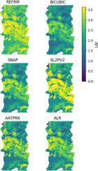
Achieving the Global Climate Observing System goal of 10 m resolution leaf area index (LAI) maps is critical for applications related to climate adaptation, sustainable agriculture, and ecosystem monitoring. Five strategies for producing 10 m LAI maps from Sentinel-2 (S2) imagery are evaluated: i. bi-cubic interpolation of 20 m resolution S2 LAI maps from the Simplified Level 2 Prototype Processor Version 1 (SL2PV1) as currently performed by the Sentinel Applications Platform (SNAP), ii. applying SL2PV1 to S2 reflectance bands spatially downscaled to 10 m using bi-cubic interpolation (BICUBIC), iii. Applying SL2PV1 to S2 reflectance bands spatially downscaled to 10 m using Area to Point Regression Kriging (ATPRK), iv. using a recalibrated version of SL2PV1 (SL2PV2) requiring only three S2 10m bands, and iv) a novel use of the previously developed Active Learning Regularization (ALR) approach to locally approximate the SL2PV1 algorithm using only 10 m bands.
中文翻译:

不仅仅是一幅漂亮的图片:使用 Sentinel-2 以 10 m 分辨率绘制叶面积指数图
实现全球气候观测系统 10 m 分辨率叶面积指数 (LAI) 地图的目标对于气候适应、可持续农业和生态系统监测相关应用至关重要。评估了从 Sentinel-2 (S2) 图像生成 10 m LAI 地图的五种策略: ii. 来自简化 2 级原型处理器版本 1 (SL2PV1) 的 20 m 分辨率 S2 LAI 地图的双三次插值,目前由 Sentinel 应用平台 (SNAP) 执行。使用双三次插值 (BICUBIC) 将 SL2PV1 应用于空间缩小至 10 m 的 S2 反射带,iii。使用面积到点回归克里金法 (ATPRK) 将 SL2PV1 应用于空间缩小至 10 m 的 S2 反射带,iv。使用仅需要三个 S2 10m 频段的 SL2PV1 (SL2PV2) 重新校准版本,以及 iv) 新颖地使用先前开发的主动学习正则化 (ALR) 方法,仅使用 10 m 频段来局部逼近 SL2PV1 算法。
更新日期:2024-06-28
中文翻译:
不仅仅是一幅漂亮的图片:使用 Sentinel-2 以 10 m 分辨率绘制叶面积指数图
实现全球气候观测系统 10 m 分辨率叶面积指数 (LAI) 地图的目标对于气候适应、可持续农业和生态系统监测相关应用至关重要。评估了从 Sentinel-2 (S2) 图像生成 10 m LAI 地图的五种策略: ii. 来自简化 2 级原型处理器版本 1 (SL2PV1) 的 20 m 分辨率 S2 LAI 地图的双三次插值,目前由 Sentinel 应用平台 (SNAP) 执行。使用双三次插值 (BICUBIC) 将 SL2PV1 应用于空间缩小至 10 m 的 S2 反射带,iii。使用面积到点回归克里金法 (ATPRK) 将 SL2PV1 应用于空间缩小至 10 m 的 S2 反射带,iv。使用仅需要三个 S2 10m 频段的 SL2PV1 (SL2PV2) 重新校准版本,以及 iv) 新颖地使用先前开发的主动学习正则化 (ALR) 方法,仅使用 10 m 频段来局部逼近 SL2PV1 算法。


 京公网安备 11010802027423号