Applied Water Science ( IF 5.7 ) Pub Date : 2024-06-21 , DOI: 10.1007/s13201-024-02217-z Hazem Ghassan Abdo , Dinesh Kumar Vishwakarma , Karam Alsafadi , Ahmed Ali Bindajam , Javed Mallick , Suraj Kumar Mallick , Karikkathil C. Arun Kumar , Jasem A. Albanai , Alban Kuriqi , Artan Hysa
|
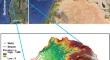
In light of population growth and climate change, groundwater is one of the most important water resources globally. Groundwater is crucial for sustaining many vital sectors in Syria, including industrial and agricultural sectors. However, groundwater exploitation has significantly escalated to meet different water needs especially in the post-war period and the earthquake disaster. Therefore, the goal was this study delineation of the groundwater potential zones (GPZs) by integrating the analytic hierarchy process (AHP) method in a geographic information systems (GIS) within the AlAlqerdaha river basin in western Syria. In this study, ten criteria were used to map the spatial distribution of GPZs, including slope, geomorphology, drainage density, land use/land cover (LU/LC), lineament density, lithology, rainfall, soil, curvature and topographic wetness index (TWI). GPZs map was validated by using the location of 74 wells and the Receiver Operating Characteristic Curve (ROC). The findings suggest that the study area is divided into five GPZs: very low, 21.39 km2 (10.87%); low, 52.45 km2 (26.65%); moderate, 65.64 km2 (33.35%); high, 40.45 km2 (20.55%) and very high, 16.90 km2 (8.58%). High and very high zones mainly corresponded to the western regions of the study area. The conducted spatial modeling indicated that the AHP-based GPZs map showed a remarkably acceptable correlation with wells locations (AUC = 87.7%, n = 74), demonstrating the precision of the AHP–GIS as a rating method. The results of this study provide objective and constructive outputs that can help decision-makers to optimally manage groundwater resources in the post-war phase in Syria.
中文翻译:
基于 GIS 的多标准决策,用于划定东地中海可持续资源管理的潜在地下水补给区:案例研究
鉴于人口增长和气候变化,地下水是全球最重要的水资源之一。地下水对于维持叙利亚许多重要部门(包括工业和农业部门)至关重要。然而,为了满足不同的用水需求,特别是在战后和地震灾害期间,地下水开采量大幅增加。因此,本研究的目标是通过将层次分析法 (AHP) 方法集成到叙利亚西部 Alqerdaha 河流域的地理信息系统 (GIS) 中来划定地下水潜力区 (GPZ)。本研究采用十个标准来绘制GPZ的空间分布图,包括坡度、地貌、排水密度、土地利用/土地覆盖(LU/LC)、线理密度、岩性、降雨量、土壤、曲率和地形湿度指数( TWI)。 GPZ 地图通过使用 74 口井的位置和接收者操作特征曲线 (ROC) 进行验证。研究结果表明,研究区分为 5 个 GPZ:非常低,21.39 km 2 (10.87%);低,52.45 公里 2 (26.65%);中等,65.64 公里 2 (33.35%);高,40.45 公里 2 (20.55%) 和非常高,16.90 公里 2 (8.58%)。高地和极高地主要对应研究区的西部地区。进行的空间建模表明,基于 AHP 的 GPZ 地图与井位置具有非常可接受的相关性(AUC = 87.7%,n = 74),证明了 AHP-GIS 作为评级方法的精度。这项研究的结果提供了客观和建设性的成果,可以帮助决策者在叙利亚战后阶段优化管理地下水资源。


 京公网安备 11010802027423号