当前位置:
X-MOL 学术
›
Basin Res.
›
论文详情
Our official English website, www.x-mol.net, welcomes your
feedback! (Note: you will need to create a separate account there.)
Drainage reorganization and divide migration driven by basin subsidence: An example from the Micang Shan, outskirts of eastern Tibet and its implications for Cenozoic evolution of the Yangtze River
Basin Research ( IF 2.8 ) Pub Date : 2024-05-28 , DOI: 10.1111/bre.12875 Yijia Ye 1 , Xibin Tan 2 , Yiduo Liu 2, 3 , Shuang Bian 1 , Chao Zhou 1 , Xun Zeng 1 , Feng Shi 1 , Mingxing Gao 4
Basin Research ( IF 2.8 ) Pub Date : 2024-05-28 , DOI: 10.1111/bre.12875 Yijia Ye 1 , Xibin Tan 2 , Yiduo Liu 2, 3 , Shuang Bian 1 , Chao Zhou 1 , Xun Zeng 1 , Feng Shi 1 , Mingxing Gao 4
Affiliation

|
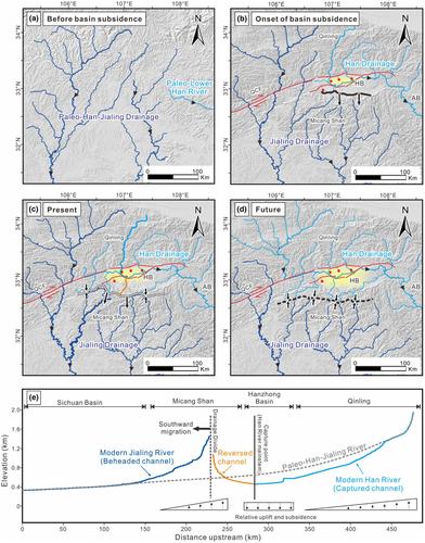
The Cenozoic India‐Asia collision has elevated the Tibetan Plateau and produced large strike‐slip faults in the interior and margins of the plateau, which profoundly influenced drainage reorganization and divide migration in Asia. Recent studies have revealed that the drainage divides between the major rivers in and around the Tibetan Plateau have been migrating for tens of millions of years, due to tectonic and/or climatic disturbance or river capture events. Drainage‐divide stability analysis can provide new, independent insights into the Cenozoic evolution of the river systems. In this study, we focus on the Hanzhong Basin and the adjacent Micang Shan (Shan means Mountain(s)) at the tail of the Qingchuan strike‐slip fault in the outskirts of eastern Tibet. We investigated the stability of the Micang Shan drainage divide, which separates the Han and Jialing rivers (two major tributaries of the Yangtze River), using two methods—χ ‐plot and Gilbert metrics. The results show that most segments of the Micang Shan drainage divide are either moving south or stable. We further calculated the predicted stable divide location and identified the abandoned river channels and residual planation surfaces. Based on these analyses, we suggest that (1) the migration of the Micang Shan drainage divide is driven by the tectonic subsidence of the Hanzhong Basin; and (2) the upper reaches of the Han River flowed southward to the Sichuan Basin before basin subsidence. This study supports the hypothesis that the Palaeo‐Middle Yangtze River and its tributaries primarily flowed southward. Moreover, the flow direction of the Middle Yangtze River has been, and still is, transitioning from southward to eastward. The change in river network flow direction is driven by regional block tilting towards the east, surface deformation from strike‐slip faulting, regional extension east of the Tibetan Plateau and/or increased influence from the summer monsoon.
中文翻译:

盆地沉降驱动的水系重组与分水岭迁移——以藏东郊区米仓山为例及其对长江新生代演化的启示
新生代印亚碰撞使青藏高原抬升,在青藏高原内部和边缘产生了大型走滑断裂,深刻影响了亚洲的水系重组和分水岭迁移。最近的研究表明,由于构造和/或气候扰动或河流侵占事件,青藏高原及其周边地区主要河流之间的水系分水岭已经迁移了数千万年。排水分流稳定性分析可以为河流系统的新生代演化提供新的、独立的见解。本研究重点关注藏东郊区青川走滑断层尾部的汉中盆地和毗邻的米仓山。我们使用 χ2 图和吉尔伯特度量两种方法研究了分隔汉江和嘉陵江(长江的两条主要支流)的米仓山流域分水岭的稳定性。结果表明,米仓山流域分水岭大部分段要么南移,要么稳定。我们进一步计算了预测的稳定分水岭位置,并确定了废弃的河道和剩余的夷平面。基于这些分析,我们认为:(1)米仓山水系分水岭的迁移是由汉中盆地的构造沉降驱动的; (2)盆地沉降前汉江上游南流至四川盆地。这项研究支持了古长江中游及其支流主要向南流动的假设。而且,长江中游的水流方向已经并且仍然是由南流向东流转变。 河网流向的变化是由区域地块向东倾斜、走滑断层引起的地表变形、青藏高原向东的区域延伸和/或夏季风的影响增加所驱动的。
更新日期:2024-05-28
中文翻译:

盆地沉降驱动的水系重组与分水岭迁移——以藏东郊区米仓山为例及其对长江新生代演化的启示
新生代印亚碰撞使青藏高原抬升,在青藏高原内部和边缘产生了大型走滑断裂,深刻影响了亚洲的水系重组和分水岭迁移。最近的研究表明,由于构造和/或气候扰动或河流侵占事件,青藏高原及其周边地区主要河流之间的水系分水岭已经迁移了数千万年。排水分流稳定性分析可以为河流系统的新生代演化提供新的、独立的见解。本研究重点关注藏东郊区青川走滑断层尾部的汉中盆地和毗邻的米仓山。我们使用 χ2 图和吉尔伯特度量两种方法研究了分隔汉江和嘉陵江(长江的两条主要支流)的米仓山流域分水岭的稳定性。结果表明,米仓山流域分水岭大部分段要么南移,要么稳定。我们进一步计算了预测的稳定分水岭位置,并确定了废弃的河道和剩余的夷平面。基于这些分析,我们认为:(1)米仓山水系分水岭的迁移是由汉中盆地的构造沉降驱动的; (2)盆地沉降前汉江上游南流至四川盆地。这项研究支持了古长江中游及其支流主要向南流动的假设。而且,长江中游的水流方向已经并且仍然是由南流向东流转变。 河网流向的变化是由区域地块向东倾斜、走滑断层引起的地表变形、青藏高原向东的区域延伸和/或夏季风的影响增加所驱动的。


 京公网安备 11010802027423号