Our official English website, www.x-mol.net, welcomes your
feedback! (Note: you will need to create a separate account there.)
Simulating water dynamics related to pedogenesis across space and time: Implications for four-dimensional digital soil mapping
Geoderma ( IF 5.6 ) Pub Date : 2024-05-27 , DOI: 10.1016/j.geoderma.2024.116911 Phillip R. Owens , Marcelo Mancini , Edwin H. Winzeler , Quentin Read , Ning Sun , Joshua Blackstock , Zamir Libohova
Geoderma ( IF 5.6 ) Pub Date : 2024-05-27 , DOI: 10.1016/j.geoderma.2024.116911 Phillip R. Owens , Marcelo Mancini , Edwin H. Winzeler , Quentin Read , Ning Sun , Joshua Blackstock , Zamir Libohova
|
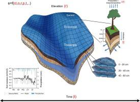
Digital soil mapping (DSM) relies on machine-learning and geostatistics to represent soil property observations across space. DSM techniques are powerful but often empirical, being limited to the quality and density of point samples. Water dynamics are closely related to soil variability, and the physics that govern water movement are well known. Hydrological properties can hence be simulated by physical models through space and time, unveiling key characteristics about soils. We propose the use of hydrologic models to map soils across the surface (2D), depth (1D), and time (1D)–which provides a 4D approach to digital soil mapping (4DSM). The Distributed Hydrology Soil Vegetation Model (DHSVM) was applied to a watershed currently under pasture. Moisture sensors and wells were installed at different depths in the watershed on summit, sideslope and toeslope positions to validate the model. DHSVM simulations of soil moisture distribution and depth to saturation were performed during the hydrological year (October 2008-September 2009). Clusters of similar pixels based on soil moisture values were determined using Dynamic Time Warping (DTW) to align temporal data and K-means. Clustering was performed both seasonally and for the entire year. Temporal patterns simulated by DHSVM matched measurements given by moisture sensors and wells. Seasonal clusters differed from the annual cluster. Distinct clusters were observed for each season and with depth, showing that spatiotemporal soil variability is lost when statically assessing soils. Spatiotemporal clusters corroborated field observations of fragipan occurrence not explicitly spatially mapped by Soil Survey Geographic Database (SSURGO). If a connection can be made between water and soils, static and dynamic soil variability can be predicted using physically based hydrologic models. Hydrologic models can benefit soil mapping by enabling reliable 4D simulation of water dynamics, which are fundamental to soil variability and soil classification and directly relate to biological, physical and chemical soil processes not captured by typical soil sampling protocols.
中文翻译:

模拟与跨空间成土过程相关的水动力学:四维数字土壤测绘的意义
数字土壤测绘 (DSM) 依靠机器学习和地统计学来表示跨空间的土壤特性观测结果。 DSM 技术很强大,但通常是经验性的,受限于点样本的质量和密度。水动力学与土壤变化密切相关,控制水运动的物理原理是众所周知的。因此,可以通过空间和时间的物理模型来模拟水文特性,揭示土壤的关键特征。我们建议使用水文模型来绘制地表 (2D)、深度 (1D) 和时间 (1D) 的土壤图,这为数字土壤测图 (4DSM) 提供了 4D 方法。分布式水文土壤植被模型(DHSVM)应用于目前牧场下的流域。在流域的山顶、边坡和坡脚位置的不同深度安装了湿度传感器和水井来验证模型。在水文年(2008年10月-2009年9月)期间进行了土壤湿度分布和饱和深度的DHSVM模拟。使用动态时间规整 (DTW) 来确定基于土壤湿度值的相似像素簇,以对齐时间数据和 K 均值。聚类按季节和全年进行。 DHSVM 模拟的时间模式与湿度传感器和井给出的测量结果相匹配。季节性集群与年度集群不同。每个季节和深度都观察到不同的簇,表明静态评估土壤时会丢失土壤时空变异性。时空聚类证实了土壤调查地理数据库 (SSURGO) 未明确空间映射的 fragipan 发生的现场观察。 如果可以在水和土壤之间建立联系,则可以使用基于物理的水文模型来预测静态和动态土壤变化。水文模型可以通过可靠的水动力学 4D 模拟来有益于土壤测绘,水动力学是土壤变异和土壤分类的基础,并且与典型土壤采样协议未捕获的生物、物理和化学土壤过程直接相关。
更新日期:2024-05-27
中文翻译:
模拟与跨空间成土过程相关的水动力学:四维数字土壤测绘的意义
数字土壤测绘 (DSM) 依靠机器学习和地统计学来表示跨空间的土壤特性观测结果。 DSM 技术很强大,但通常是经验性的,受限于点样本的质量和密度。水动力学与土壤变化密切相关,控制水运动的物理原理是众所周知的。因此,可以通过空间和时间的物理模型来模拟水文特性,揭示土壤的关键特征。我们建议使用水文模型来绘制地表 (2D)、深度 (1D) 和时间 (1D) 的土壤图,这为数字土壤测图 (4DSM) 提供了 4D 方法。分布式水文土壤植被模型(DHSVM)应用于目前牧场下的流域。在流域的山顶、边坡和坡脚位置的不同深度安装了湿度传感器和水井来验证模型。在水文年(2008年10月-2009年9月)期间进行了土壤湿度分布和饱和深度的DHSVM模拟。使用动态时间规整 (DTW) 来确定基于土壤湿度值的相似像素簇,以对齐时间数据和 K 均值。聚类按季节和全年进行。 DHSVM 模拟的时间模式与湿度传感器和井给出的测量结果相匹配。季节性集群与年度集群不同。每个季节和深度都观察到不同的簇,表明静态评估土壤时会丢失土壤时空变异性。时空聚类证实了土壤调查地理数据库 (SSURGO) 未明确空间映射的 fragipan 发生的现场观察。 如果可以在水和土壤之间建立联系,则可以使用基于物理的水文模型来预测静态和动态土壤变化。水文模型可以通过可靠的水动力学 4D 模拟来有益于土壤测绘,水动力学是土壤变异和土壤分类的基础,并且与典型土壤采样协议未捕获的生物、物理和化学土壤过程直接相关。


 京公网安备 11010802027423号