当前位置:
X-MOL 学术
›
Tectonophysics
›
论文详情
Our official English website, www.x-mol.net, welcomes your
feedback! (Note: you will need to create a separate account there.)
Two-stage expansion of the South Qilian Shan during the mid-Miocene: Insights from provenance analysis in the northern Qaidam Basin, NW China
Tectonophysics ( IF 2.7 ) Pub Date : 2024-04-02 , DOI: 10.1016/j.tecto.2024.230304 Wen-jun Zheng , Bing-xu Liu , Lei Duan , Wei-tao Wang , Xin Sun
Tectonophysics ( IF 2.7 ) Pub Date : 2024-04-02 , DOI: 10.1016/j.tecto.2024.230304 Wen-jun Zheng , Bing-xu Liu , Lei Duan , Wei-tao Wang , Xin Sun
|
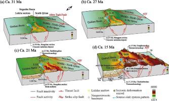
The remote effects of the collision between India and Eurasia since the Cenozoic have led to complex tectonic deformation patterns in the northern Tibetan Plateau. The thick Cenozoic strata in the Qaidam Basin, located in the northern Tibetan Plateau, record comprehensive information about this process. This study combines detrital zircon UPb geochronology, heavy mineral analysis, and paleocurrent analysis along the Lulehe section and modern rivers in the northern Qaidam Basin to characterize sediment provenance shifts. The modern river debris suggests that the sedimentary fill in the northern Qaidam Basin mainly comes from the pre–Cenozoic basement and the Neoproterozoic basement that is now exposed in and around the South Qilianshan. The detrital zircon grains from the Lulehe section primarily have ages corresponding to the early Paleozoic (400–500 Ma), Neoproterozoic (700–900 Ma), Paleoproterozoic (1500–2100 Ma), and Neoarchean (2500–2800 Ma). The age composition of detrital zircon in the Lulehe section significantly deviates from other representative sections in the northern Qaidam Basin, primarily due to a notably higher abundance of Neoproterozoic detrital zircon grains that have rarely been documented regarding their provenance. Sandstone samples heavy mineral provenance shows clear spatiotemporal variations. These results suggest four provenance shifts in the Cenozoic strata in the northern Qaidam Basin. These shifts were associated with two phases of significant topographic growth in the South Qilian Shan. During the first phase, the South Qilianshan underwent tectonic uplift and provided clastic materials to the Qaidam Basin at ca. 31 Ma. Then, the Saishiteng–Aolaoshan in the northern basin experienced two stages of topographic growth at ca. 27 and 21 Ma and became one of the sediment sources. In a later phase, the Qilianshan experienced large-scale synchronous tectonic uplift at ca. 15 Ma, and the modern landforms and water system pattern in the northern Tibetan Plateau were formed at this time.
中文翻译:

中新世中期南祁连山的两阶段扩张:柴达木盆地北部物源分析的启示
新生代以来印度与欧亚大陆碰撞的远程影响导致了青藏高原北部复杂的构造变形模式。位于青藏高原北部的柴达木盆地厚厚的新生代地层记录了这一过程的全面信息。本研究结合了柴达木盆地北部路勒河剖面和现代河流的碎屑锆石 UPb 年代学、重矿物分析和古水流分析,以表征沉积物物源变化。现代河流碎屑表明,柴达木盆地北部的沉积充填物主要来自前新生代基底和现出露于南祁连山及其周围的新元古代基底。吕勒河剖面碎屑锆石颗粒的年龄主要对应于早古生代(400~500 Ma)、新元古代(700~900 Ma)、古元古代(1500~2100 Ma)和新太古代(2500~2800 Ma)。路勒河剖面碎屑锆石年龄组成与柴达木盆地北部其他代表性剖面存在显着差异,主要原因是新元古代碎屑锆石颗粒丰度明显较高,而其物源却鲜有记录。砂岩样品重矿物来源显示出明显的时空变化。这些结果表明柴达木盆地北部新生代地层发生了四次物源变化。这些变化与南祁连山地形显着增长的两个阶段有关。第一阶段,南祁连山经历了构造隆升,为柴达木盆地提供了碎屑物质。 31马。此后,盆地北部的赛什腾—敖老山在大约 1997 年经历了两个地形生长阶段。 27、21Ma,成为沉积物来源之一。在后期,祁连山在大约 10 世纪经历了大规模的同步构造隆升。 15Ma,藏北高原现代地貌和水系格局正是在此时形成。
更新日期:2024-04-02
中文翻译:
中新世中期南祁连山的两阶段扩张:柴达木盆地北部物源分析的启示
新生代以来印度与欧亚大陆碰撞的远程影响导致了青藏高原北部复杂的构造变形模式。位于青藏高原北部的柴达木盆地厚厚的新生代地层记录了这一过程的全面信息。本研究结合了柴达木盆地北部路勒河剖面和现代河流的碎屑锆石 UPb 年代学、重矿物分析和古水流分析,以表征沉积物物源变化。现代河流碎屑表明,柴达木盆地北部的沉积充填物主要来自前新生代基底和现出露于南祁连山及其周围的新元古代基底。吕勒河剖面碎屑锆石颗粒的年龄主要对应于早古生代(400~500 Ma)、新元古代(700~900 Ma)、古元古代(1500~2100 Ma)和新太古代(2500~2800 Ma)。路勒河剖面碎屑锆石年龄组成与柴达木盆地北部其他代表性剖面存在显着差异,主要原因是新元古代碎屑锆石颗粒丰度明显较高,而其物源却鲜有记录。砂岩样品重矿物来源显示出明显的时空变化。这些结果表明柴达木盆地北部新生代地层发生了四次物源变化。这些变化与南祁连山地形显着增长的两个阶段有关。第一阶段,南祁连山经历了构造隆升,为柴达木盆地提供了碎屑物质。 31马。此后,盆地北部的赛什腾—敖老山在大约 1997 年经历了两个地形生长阶段。 27、21Ma,成为沉积物来源之一。在后期,祁连山在大约 10 世纪经历了大规模的同步构造隆升。 15Ma,藏北高原现代地貌和水系格局正是在此时形成。


 京公网安备 11010802027423号