Landscape Ecology ( IF 4.0 ) Pub Date : 2024-02-14 , DOI: 10.1007/s10980-024-01846-8 Mojdeh Miraki , Hormoz Sohrabi , Parviz Fatehi , Mathias Kneubuehler
|
Context
Mapping the distribution of species, especially those that are endemic and endangered like certain tree species, is a vital step in the effective planning and execution of conservation programs and monitoring efforts. This task gains even more significance as it directly contributes to forest conservation by highlighting the importance of species diversity.
Objectives
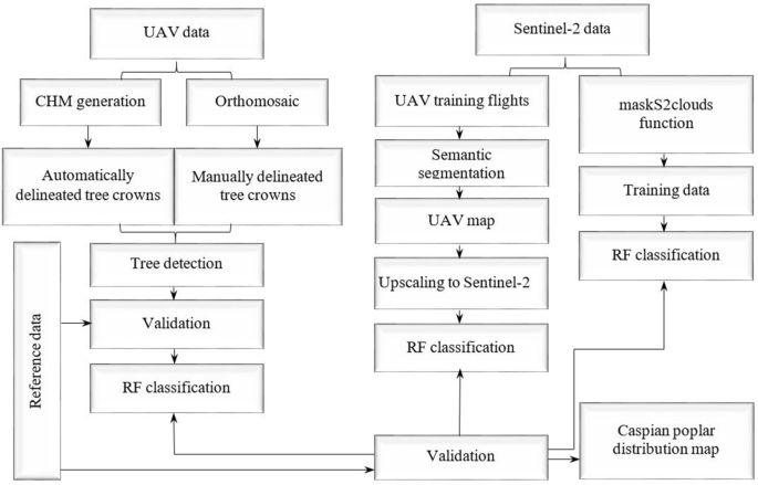
Our study objective was to assess the detection accuracy of a specific tree using different remote sensing sources and approaches.
Methods
Initially, individual trees were identified and classified using a canopy height model derived from UAV data. Next, we carried out the classification of satellite data within the Google Earth Engine. Lastly, we scaled the UAV-RGB dataset to match the spatial resolution of Sentinel-2, which was then employed to train random forest models using the multispectral data from Sentinel-2.
Results
For the UAV data, we achieved overall accuracies of 56% for automatically delineated tree crowns and 83% for manually delineated ones. Regarding the second approach using Sentinel-2 data, the classification in the Noor forest yielded an overall accuracy of 74% and a Kappa coefficient of 0.57, while in the Safrabasteh forest, the accuracy was 80% with a Kappa of 0.61. In the third approach, our findings indicate an improvement compared to the second approach, with the overall accuracy and Kappa coefficient of the classification rising to 82% and 0.68, respectively.
Conclusions
In this study, it was found that according to the purpose and available facilities, satellite and UAV data can be successfully used to identify a specific tree species.
中文翻译:
耦合无人机和卫星数据进行树种识别以绘制里海杨树的分布图
语境
绘制物种的分布图,特别是那些像某些树种这样的特有物种和濒危物种的分布图,是有效规划和执行保护计划和监测工作的重要一步。这项任务变得更加重要,因为它通过强调物种多样性的重要性来直接促进森林保护。
目标
我们的研究目标是使用不同的遥感源和方法评估特定树木的检测准确性。
方法
最初,使用从无人机数据导出的树冠高度模型来识别和分类单棵树。接下来,我们在 Google Earth Engine 中对卫星数据进行了分类。最后,我们缩放了 UAV-RGB 数据集以匹配 Sentinel-2 的空间分辨率,然后使用 Sentinel-2 的多光谱数据来训练随机森林模型。
结果
对于无人机数据,我们自动描绘的树冠的总体准确度为 56%,手动描绘的树冠的总体准确度为 83%。对于使用 Sentinel-2 数据的第二种方法,Noor 森林中的分类总体准确率为 74%,Kappa 系数为 0.57,而在 Safrabasteh 森林中,分类准确率为 80%,Kappa 为 0.61。在第三种方法中,我们的研究结果表明与第二种方法相比有所改进,分类的总体准确率和 Kappa 系数分别上升到 82% 和 0.68。
结论
在这项研究中,发现根据目的和现有设施,卫星和无人机数据可以成功地用于识别特定的树种。


 京公网安备 11010802027423号