当前位置:
X-MOL 学术
›
Remote Sens. Ecol. Conserv.
›
论文详情
Our official English website, www.x-mol.net, welcomes your
feedback! (Note: you will need to create a separate account there.)
Assessing the accuracy of georeferenced landcover data derived from oblique imagery using machine learning
Remote Sensing in Ecology and Conservation ( IF 3.9 ) Pub Date : 2024-01-04 , DOI: 10.1002/rse2.379 James Tricker 1 , Claire Wright 1 , Spencer Rose 1 , Jeanine Rhemtulla 2 , Trevor Lantz 1 , Eric Higgs 1
Remote Sensing in Ecology and Conservation ( IF 3.9 ) Pub Date : 2024-01-04 , DOI: 10.1002/rse2.379 James Tricker 1 , Claire Wright 1 , Spencer Rose 1 , Jeanine Rhemtulla 2 , Trevor Lantz 1 , Eric Higgs 1
Affiliation

|
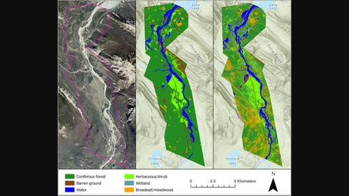
Repeat photography offers distinctive insights into ecological change, with ground-based oblique photographs often predating early aerial images by decades. However, the oblique angle of the photographs presents challenges for extracting and analyzing ecological information using traditional remote sensing approaches. Several innovative methods have been developed for analyzing repeat photographs, but none offer a comprehensive end-to-end workflow incorporating image classification and georeferencing to produce quantifiable landcover data. In this paper, we provide an overview of two new tools, an automated deep learning classifier and intuitive georeferencing tool, and describe how they are used to derive landcover data from 19 images associated with the Mountain Legacy Project, a research team that works with the world's largest collection of systematic high-resolution historic mountain photographs. We then combined these data to produce a contemporary landcover map for a study area in Jasper National Park, Canada. We assessed georeferencing accuracy by calculating the root-mean-square error and mean displacement for a subset of the images, which was 4.6 and 3.7 m, respectively. Overall classification accuracy of the landcover map produced from oblique images was 68%, which was comparable to landcover data produced from aerial imagery using a conventional classification method. The new workflow advances the use of repeat photographs for yielding quantitative landcover data. It has several advantages over existing methods including the ability to produce quick and consistent image classifications with little human input, and accurately georeference and combine these data to generate landcover maps for large areas.
中文翻译:

使用机器学习评估从倾斜图像导出的地理参考土地覆盖数据的准确性
重复摄影为生态变化提供了独特的见解,地面倾斜照片通常比早期航空图像早数十年。然而,照片的倾斜角度给使用传统遥感方法提取和分析生态信息带来了挑战。已经开发了几种创新方法来分析重复照片,但没有一种方法提供综合的端到端工作流程,结合图像分类和地理配准来生成可量化的土地覆盖数据。在本文中,我们概述了两种新工具,即自动深度学习分类器和直观的地理配准工具,并描述了如何使用它们从与 Mountain Legacy Project(与 Mountain Legacy Project 合作的研究团队)相关的 19 张图像中获取土地覆盖数据。世界上最大的系统高分辨率历史山地照片集。然后,我们结合这些数据,为加拿大贾斯珀国家公园的一个研究区域制作了一幅当代土地覆盖地图。我们通过计算图像子集的均方根误差和平均位移(分别为 4.6 和 3.7 m)来评估地理配准精度。由倾斜图像生成的土地覆盖图的总体分类准确度为 68%,与使用传统分类方法根据航空影像生成的土地覆盖数据相当。新的工作流程推进了重复照片的使用,以生成定量的土地覆盖数据。与现有方法相比,它具有多个优点,包括能够在几乎不需要人工输入的情况下生成快速且一致的图像分类,以及准确地进行地理配准并结合这些数据来生成大面积的土地覆盖地图。
更新日期:2024-01-06
中文翻译:

使用机器学习评估从倾斜图像导出的地理参考土地覆盖数据的准确性
重复摄影为生态变化提供了独特的见解,地面倾斜照片通常比早期航空图像早数十年。然而,照片的倾斜角度给使用传统遥感方法提取和分析生态信息带来了挑战。已经开发了几种创新方法来分析重复照片,但没有一种方法提供综合的端到端工作流程,结合图像分类和地理配准来生成可量化的土地覆盖数据。在本文中,我们概述了两种新工具,即自动深度学习分类器和直观的地理配准工具,并描述了如何使用它们从与 Mountain Legacy Project(与 Mountain Legacy Project 合作的研究团队)相关的 19 张图像中获取土地覆盖数据。世界上最大的系统高分辨率历史山地照片集。然后,我们结合这些数据,为加拿大贾斯珀国家公园的一个研究区域制作了一幅当代土地覆盖地图。我们通过计算图像子集的均方根误差和平均位移(分别为 4.6 和 3.7 m)来评估地理配准精度。由倾斜图像生成的土地覆盖图的总体分类准确度为 68%,与使用传统分类方法根据航空影像生成的土地覆盖数据相当。新的工作流程推进了重复照片的使用,以生成定量的土地覆盖数据。与现有方法相比,它具有多个优点,包括能够在几乎不需要人工输入的情况下生成快速且一致的图像分类,以及准确地进行地理配准并结合这些数据来生成大面积的土地覆盖地图。


 京公网安备 11010802027423号