当前位置:
X-MOL 学术
›
Earth Surf.Process. Land.
›
论文详情
Our official English website, www.x-mol.net, welcomes your
feedback! (Note: you will need to create a separate account there.)
Reconstructing basal ice flow patterns of the Last Glacial Maximum Rhine glacier (northern Alpine foreland) based on streamlined subglacial landforms
Earth Surface Processes and Landforms ( IF 2.8 ) Pub Date : 2023-11-13 , DOI: 10.1002/esp.5733
Sarah Kamleitner 1 , Susan Ivy‐Ochs 1 , Bernhard Salcher 2 , Jürgen M. Reitner 3
Earth Surface Processes and Landforms ( IF 2.8 ) Pub Date : 2023-11-13 , DOI: 10.1002/esp.5733
Sarah Kamleitner 1 , Susan Ivy‐Ochs 1 , Bernhard Salcher 2 , Jürgen M. Reitner 3
Affiliation
|
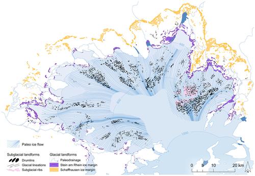
Based on high-resolution (sub)glacial geomorphological mapping, we present a first digital inventory of streamlined bedforms within the footprint of a Last Glacial Maximum (LGM) Alpine piedmont glacier. A total of 2460 drumlins were mapped across the Rhine glacier foreland. Glacial lineations and one field of subglacial ribs (ribbed/Rogen moraines) — the first record of this type of subglacial landform on the Alpine foreland—were identified. Two flowsets, associated with (i) the Rhine glacier's LGM maximum advance (Schaffhausen stadial) and (ii) a late LGM readvance (Stein am Rhein stadial), are differentiated. The vast majority of streamlined bedforms occur in fields aligned in a 16- to 30-km-wide swath upstream of the Stein am Rhein frontal moraines. Orientation and elongation of drumlins and glacial lineations set the basis for the reconstruction of paleo-ice flow. Basal flow paths of the LGM maximum advance are visually interpreted and restricted to the zone proximal to the former ice front. The flow field reconstructed for the late LGM glacier readvance (Stein am Rhein stadial) extends tens of kilometres upstream and is modelled implementing a recently published kriging routine. The derived basal flow patterns paired with information on ice surface levels from lateral and frontal moraines and combined with relative ice velocity differences inferred from spatial changes in bedform elongation reveal detailed insights on ice flow geometries, particularly during the glacier readvance. Reconstructed flowlines highlight basal flow under shallow ice that is strongly controlled by local topography evidenced by diverging around basal bumps and converging in (narrow) valley sections and troughs, where basal flow velocities, steered by topography, are high. Gained paleo-ice basal flow patterns offer new insights on landscape evolution of the northern Alpine foreland and provide evidence-based flow data to validate future physical modelling results.
中文翻译:

基于流线型冰下地貌重建末次盛冰期莱茵冰川(北部高山前陆)基底冰流模式
基于高分辨率冰河下地貌测绘,我们首次展示了末次盛冰期 (LGM) 高山山前冰川足迹内流线型地床形态的数字清单。莱茵冰川前陆共绘制了 2460 个鼓点。确定了冰川线和一片冰下肋骨(肋状/罗根冰碛)——阿尔卑斯山前陆此类冰下地貌的第一个记录。与 (i) 莱茵冰川末次盛冰期最大提前量 (Schaffhausen stadial) 和 (ii) 末期盛冰期再提前量 (Stein am Rhein stadial) 相关的两个流集是有区别的。绝大多数流线型河床出现在施泰因额冰碛上游 16 至 30 公里宽的地带中。鼓点和冰川线纹的方向和伸长为重建古冰流奠定了基础。末次海冰最大推进的基底流动路径可以通过视觉解释并限制在靠近前冰锋的区域。为末次盛冰期冰川再推进(Stein am Rhein stadial)重建的流场向上游延伸数十公里,并根据最近发布的克里金法程序进行建模。得出的基础流模式与侧向和锋面冰碛的冰面水平信息相结合,并与从床形伸长的空间变化推断出的相对冰速差异相结合,揭示了对冰流几何形状的详细见解,特别是在冰川重新推进期间。重建的流线突出显示了浅冰下的基础流,其受到当地地形的强烈控制,这可以通过在基础凸起周围发散并在(狭窄的)山谷部分和槽中汇聚来证明,其中受地形控制的基础流速很高。获得的古冰基底流动模式为北部高山前陆的景观演化提供了新的见解,并提供基于证据的流动数据来验证未来的物理建模结果。
更新日期:2023-11-13
中文翻译:
基于流线型冰下地貌重建末次盛冰期莱茵冰川(北部高山前陆)基底冰流模式
基于高分辨率冰河下地貌测绘,我们首次展示了末次盛冰期 (LGM) 高山山前冰川足迹内流线型地床形态的数字清单。莱茵冰川前陆共绘制了 2460 个鼓点。确定了冰川线和一片冰下肋骨(肋状/罗根冰碛)——阿尔卑斯山前陆此类冰下地貌的第一个记录。与 (i) 莱茵冰川末次盛冰期最大提前量 (Schaffhausen stadial) 和 (ii) 末期盛冰期再提前量 (Stein am Rhein stadial) 相关的两个流集是有区别的。绝大多数流线型河床出现在施泰因额冰碛上游 16 至 30 公里宽的地带中。鼓点和冰川线纹的方向和伸长为重建古冰流奠定了基础。末次海冰最大推进的基底流动路径可以通过视觉解释并限制在靠近前冰锋的区域。为末次盛冰期冰川再推进(Stein am Rhein stadial)重建的流场向上游延伸数十公里,并根据最近发布的克里金法程序进行建模。得出的基础流模式与侧向和锋面冰碛的冰面水平信息相结合,并与从床形伸长的空间变化推断出的相对冰速差异相结合,揭示了对冰流几何形状的详细见解,特别是在冰川重新推进期间。重建的流线突出显示了浅冰下的基础流,其受到当地地形的强烈控制,这可以通过在基础凸起周围发散并在(狭窄的)山谷部分和槽中汇聚来证明,其中受地形控制的基础流速很高。获得的古冰基底流动模式为北部高山前陆的景观演化提供了新的见解,并提供基于证据的流动数据来验证未来的物理建模结果。


 京公网安备 11010802027423号