Journal of Geodesy ( IF 3.9 ) Pub Date : 2023-10-27 , DOI: 10.1007/s00190-023-01790-6
Xin Yang , Wenxiang Liu , Xiaozhou Ye , Xiangjun Li , Shipeng Wei , Feixue Wang
|
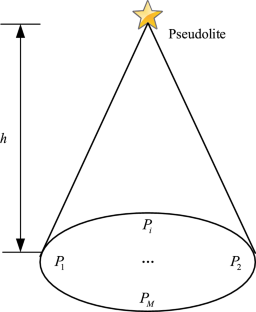
To provide users with secure and reliable navigation, positioning and timing (PNT) services, it is necessary to establish resilient PNT because global navigation satellite system (GNSS) platforms are limited by weak received power and are susceptible to interference. As a part of resilient PNT, an unmanned aerial vehicle (UAV) pseudolite navigation system can be easily used as an independent backup navigation system and an augmentation system for GNSS. When used as a backup system, good geometric dilution of precision (GDOP) performance should be provided to users. Therefore, it is critical to optimize the specific position of pseudolite systems. However, most existing layout methods are based on experience or optimization algorithms without theoretical derivation for the user layer and have defects of weak robustness or too long of a computing time. Therefore, we introduce a robust method that can quickly determine the specific location of each pseudolite system to provide better GDOP performance. To verify the performance of the method, we compared the proposed method with an empirical method and optimization methods based on the non-dominant sorting genetic algorithm II (NSGA-II) and the genetic algorithm (GA) through simulation. The results showed that the proposed method not only has a shorter computing time but can also provide more accurate positioning services for users with a smaller GDOP. Furthermore, even under harsh conditions such as large region radius, it can still obtain usable results, while the other methods cannot. Moreover, we also verified the effectiveness of the proposed method using an experimental UAV with real-time positioning. The results when the UAV hovered were almost the same as the simulation results. Although the results when the UAV circled were slightly worse than when it hovered, they were still acceptable for users.
中文翻译:
基于几何的无人机伪卫星导航系统在目标区域快速部署方法
由于全球导航卫星系统(GNSS)平台受到接收功率较弱且容易受到干扰的影响,为了向用户提供安全可靠的导航、定位和授时(PNT)服务,有必要建立弹性PNT。作为弹性PNT的一部分,无人机伪卫星导航系统可以轻松用作独立的备用导航系统和GNSS增强系统。当用作备份系统时,应为用户提供良好的几何精度稀释(GDOP)性能。因此,优化伪卫星系统的具体位置至关重要。然而,现有的布局方法大多基于经验或优化算法,没有对用户层进行理论推导,存在鲁棒性弱或计算时间过长的缺陷。因此,我们引入了一种鲁棒的方法,可以快速确定每个伪卫星系统的具体位置,以提供更好的GDOP性能。为了验证该方法的性能,我们通过仿真将所提出的方法与经验方法以及基于非支配排序遗传算法II(NSGA-II)和遗传算法(GA)的优化方法进行了比较。结果表明,该方法不仅计算时间较短,而且能够以较小的GDOP为用户提供更准确的定位服务。此外,即使在大区域半径等恶劣条件下,它仍然可以获得可用的结果,而其他方法则不能。此外,我们还使用实时定位实验无人机验证了所提方法的有效性。无人机悬停时的结果与仿真结果几乎相同。虽然无人机盘旋时的效果比悬停时的效果稍差,但对于用户来说还是可以接受的。


 京公网安备 11010802027423号