当前位置:
X-MOL 学术
›
Earth Surf.Process. Land.
›
论文详情
Our official English website, www.x-mol.net, welcomes your
feedback! (Note: you will need to create a separate account there.)
Morphometric analysis of ice scour lakes in Iceland: A proxy for ice sheet dynamics
Earth Surface Processes and Landforms ( IF 2.8 ) Pub Date : 2023-09-02 , DOI: 10.1002/esp.5693 Halley M. Mastro 1 , Sarah M. Principato 1 , Ilana B. Sobel 1 , Ívar Örn Benediktsson 2 , Nína Aradóttir 2
Earth Surface Processes and Landforms ( IF 2.8 ) Pub Date : 2023-09-02 , DOI: 10.1002/esp.5693 Halley M. Mastro 1 , Sarah M. Principato 1 , Ilana B. Sobel 1 , Ívar Örn Benediktsson 2 , Nína Aradóttir 2
Affiliation

|
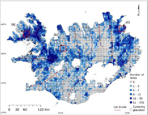
Glacial erosion rates on the Iceland landscape throughout the Pleistocene are not well quantified. Ice scour lakes provide an opportunity to investigate glacial erosive activity and relative intensity because they commonly form in areas beneath ice sheets due to intense quarrying. This study evaluates ice scour lake morphology and density as a potential proxy for paleo-ice flow direction and basal thermal regime for parts of the Iceland Ice Sheet. Using GIS analysis, properties of ice scour lakes are examined in regions that experienced different rates of ice flow during and following the Last Glacial Maximum (LGM), as interpreted from streamlined subglacial landforms. The primary input datasets were topographic, hydrologic and bedrock data. Lake distribution and morphology were quantified for all natural lakes of Iceland (n = 30 169), with close examination of three 400 km2 sub-regions in Vestfirðir (n = 904), Húnaflói (n = 69) and Bakkaheiði (n = 232). Lake distribution parameters include density, packing and centroid elevation. PolyMorph-2D was used to quantify lake morphology including orientation, area and elongation ratio. Ice scour lake density, packing and elevation were all greatest on Vestfirðir. The high density and packing of lakes across Vestfirðir suggests unique ice dynamics relative to the other two sub-regions, and multidirectional flow of lake axes supports the presence of an independent ice cap covering Vestfirðir. Differential intensity of glacial erosion interpreted from regions of high and low lake density on Bakkaheiði supports a proposed ice divide in Northeast Iceland. The orientation of lakes align with the flow directions of proposed LGM ice streams in Northern and Northeast Iceland. Ice scour lakes were most elongate on average on Bakkaheiði, which supports fast ice flow. Improving understanding of former ice sheet basal thermal regime and paleo-ice flow velocity serves to inform modern controls on ice sheet stability and ice sheet basal processes.
中文翻译:

冰岛冰冲湖的形态分析:冰盖动力学的代理
整个更新世期间冰岛景观的冰川侵蚀率尚未得到很好的量化。冰冲湖为研究冰川侵蚀活动和相对强度提供了机会,因为它们通常由于强烈的采石而形成于冰盖下方的区域。这项研究评估了冰冲刷湖的形态和密度,作为冰岛冰盖部分地区古冰流向和基础热状况的潜在指标。利用 GIS 分析,对末次盛冰期 (LGM) 期间和之后经历不同冰流速率的区域的冰冲湖特性进行了检查,并根据流线型冰下地貌进行了解释。主要输入数据集是地形、水文和基岩数据。对冰岛所有天然湖泊 ( n = 30 169) 的湖泊分布和形态进行了量化,并仔细检查了Vestfirðir ( n = 904)、Húnaflói ( n = 69) 和 Bakkaheiði ( n = 232)三个 400 km 2 的子区域)。湖泊分布参数包括密度、堆积和质心高程。PolyMorph-2D 用于量化湖泊形态,包括方向、面积和伸长比。冰冲湖的密度、填充度和海拔在 Vestfirðir 上都是最大的。西菲尔济 (Vestfirðir) 地区湖泊的高密度和密集性表明,相对于其他两个分区,冰的动力学具有独特性,而且湖轴的多向流动支持了覆盖西菲尔济 (Vestfirðir) 的独立冰盖的存在。根据 Bakkaheiði 湖泊密度高低区域解释的冰川侵蚀强度差异支持了冰岛东北部拟议的冰分界线。湖泊的方向与冰岛北部和东北部拟议的末次盛冰期冰流的流动方向一致。Bakkaheiði 上的冰冲刷湖平均最细长,支持快速的冰流。提高对前冰盖基础热状况和古冰流速的了解有助于为现代控制冰盖稳定性和冰盖基础过程提供信息。
更新日期:2023-09-02
中文翻译:

冰岛冰冲湖的形态分析:冰盖动力学的代理
整个更新世期间冰岛景观的冰川侵蚀率尚未得到很好的量化。冰冲湖为研究冰川侵蚀活动和相对强度提供了机会,因为它们通常由于强烈的采石而形成于冰盖下方的区域。这项研究评估了冰冲刷湖的形态和密度,作为冰岛冰盖部分地区古冰流向和基础热状况的潜在指标。利用 GIS 分析,对末次盛冰期 (LGM) 期间和之后经历不同冰流速率的区域的冰冲湖特性进行了检查,并根据流线型冰下地貌进行了解释。主要输入数据集是地形、水文和基岩数据。对冰岛所有天然湖泊 ( n = 30 169) 的湖泊分布和形态进行了量化,并仔细检查了Vestfirðir ( n = 904)、Húnaflói ( n = 69) 和 Bakkaheiði ( n = 232)三个 400 km 2 的子区域)。湖泊分布参数包括密度、堆积和质心高程。PolyMorph-2D 用于量化湖泊形态,包括方向、面积和伸长比。冰冲湖的密度、填充度和海拔在 Vestfirðir 上都是最大的。西菲尔济 (Vestfirðir) 地区湖泊的高密度和密集性表明,相对于其他两个分区,冰的动力学具有独特性,而且湖轴的多向流动支持了覆盖西菲尔济 (Vestfirðir) 的独立冰盖的存在。根据 Bakkaheiði 湖泊密度高低区域解释的冰川侵蚀强度差异支持了冰岛东北部拟议的冰分界线。湖泊的方向与冰岛北部和东北部拟议的末次盛冰期冰流的流动方向一致。Bakkaheiði 上的冰冲刷湖平均最细长,支持快速的冰流。提高对前冰盖基础热状况和古冰流速的了解有助于为现代控制冰盖稳定性和冰盖基础过程提供信息。


 京公网安备 11010802027423号