Environment, Development and Sustainability ( IF 4.7 ) Pub Date : 2023-08-03 , DOI: 10.1007/s10668-023-03657-4 Shravankumar Shivappa Masalvad , Chidanand Patil , Akkaram Pravalika , Basavaraj Katageri , Purandara Bekal , Prashant Patil , Nagraj Hegde , Uttam Kumar Sahoo , Praveen Kumar Sakare
|
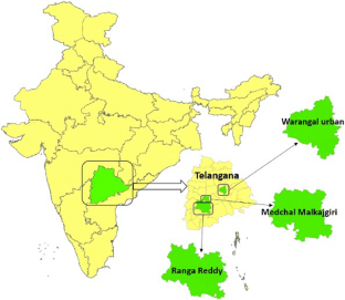
The study of changes in land use and land cover (LULC) is helpful in the understanding of change and management of environmental sustainability. As a result, the central Telangana districts are the focus of this study since they are under stress from both natural and human-caused problems. The examination of LULC variations and predictions for the region between 2007–2015 and 2021–2030 employed Landsat OLI datasets, TerrSet, and geographic information system (GIS) tools. The LULC image is produced using a Landsat dataset and classified using a support vector machine (SVM). Then, consecutively to project future LULC change, LULC maps were constructed using the CA Markov model. The four stages included were change analysis, transition possibility, change forecasting, and model validation. It is found that the vegetation and the arid landscape are stressed and accumulating. The total accuracy was above 87 percent, and the kappa statistic measurement was above 85 percent with a three-year target. The study has found using the Markov chain land change modeler that Medchal–Malkajgiri district urban settlements will grow by 46, 37, and 26% from 2021–2030, 2030–2050, and 2050–2100, respectively. On other hand, the Warangal (Hanamkonda) observed 39, 45, and 30% between 2021–2030, 2030–2050, and 2050–2100, respectively, and Rangareddy districts observed 60, 24, and 12% between 2021–2030, 2030–2050, and 2050–2100, respectively. Given that urban areas are especially susceptible to flash flooding, this research will offer policymakers advice and a framework on behalf of planning city growth and managing the available resources judiciously with utmost planning.
中文翻译:
应用地理空间技术利用CA马尔可夫链模型进行土地利用/土地覆盖变化评估和未来变化预测
研究土地利用和土地覆盖(LULC)的变化有助于理解环境可持续性的变化和管理。因此,特伦甘纳中部地区是本研究的重点,因为它们承受着自然和人为问题的压力。使用 Landsat OLI 数据集、TerrSet 和地理信息系统 (GIS) 工具对 2007-2015 年和 2021-2030 年期间的 LULC 变化和预测进行了检查。LULC 图像是使用 Landsat 数据集生成的,并使用支持向量机 (SVM) 进行分类。然后,为了预测未来的 LULC 变化,使用 CA 马尔可夫模型构建了 LULC 地图。包括四个阶段:变革分析、转型可能性、变革预测和模型验证。研究发现,植被和干旱景观受到压力和积累。总准确率高于 87%,kappa 统计测量高于 85%,三年目标为。研究发现,使用马尔可夫链土地变化模型,Medchal-Malkajgiri地区的城市住区将在2021-2030年、2030-2050年和2050-2100年分别增长46%、37%和26%。另一方面,Warangal (Hanamkonda) 在 2021-2030 年、2030-2050 年和 2050-2100 年期间分别观察到 39%、45% 和 30%,而 Rangareddy 地区在 2021-2030 年和 2030 年期间观察到 60%、24% 和 12%分别为 –2050 年和 2050–2100 年。鉴于城市地区特别容易遭受山洪爆发,


 京公网安备 11010802027423号