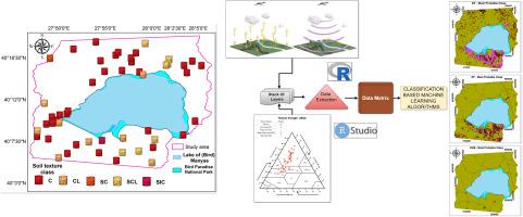
土壤质地类别 (STC) 影响土壤的物理、化学和生物特性,而准确的 STC 空间预测对于农业生态建模至关重要。本研究的目的是评估源自 Landsat 8 OLI Science 产品和数字高程模型 (DEM) 以及三种机器学习方法的环境协变量的能力,以提供准确可靠的土壤质地类别分类。使用决策树 (DT)、随机森林 (RF) 和支持向量机 (SVM) 算法在 Türkiye 西北部(马尼亚斯湖)以 Fluvisols 和 Vertisols 作为主要参考土壤组的地区研究了土壤质地类别的估计效率。使用留一法交叉验证技术对模型进行了验证。根据准确度评估,三种土壤质地分类机器学习模型中最好的是 RF,总体准确度为 0.63,kappa 指数值为 0.14。RF 算法使用混淆指数 (RF:0.30) 和丰度指数 (RF:1.0) 值作为不确定性标准,生成了一张地图,其结果与真实环境更加一致。土壤质地类别最重要的预测因子是基于树的学习算法的地形湿度指数(平均下降精度:3%),其次是基于卫星数据的其他指数。这些发现将有助于支持在表土质地多样性很大的地区采用可持续的土壤管理技术。根据准确度评价。RF 算法使用混淆指数 (RF:0.30) 和丰度指数 (RF:1.0) 值作为不确定性标准,生成了一张地图,其结果与真实环境更加一致。土壤质地类别最重要的预测因子是基于树的学习算法的地形湿度指数(平均下降精度:3%),其次是基于卫星数据的其他指数。这些发现将有助于支持在表土质地多样性很大的地区采用可持续的土壤管理技术。根据准确度评价。RF 算法使用混淆指数 (RF:0.30) 和丰度指数 (RF:1.0) 值作为不确定性标准,生成了一张地图,其结果与真实环境更加一致。土壤质地类别最重要的预测因子是基于树的学习算法的地形湿度指数(平均下降精度:3%),其次是基于卫星数据的其他指数。这些发现将有助于支持在表土质地多样性很大的地区采用可持续的土壤管理技术。土壤质地类别最重要的预测因子是基于树的学习算法的地形湿度指数(平均下降精度:3%),其次是基于卫星数据的其他指数。这些发现将有助于支持在表土质地多样性很大的地区采用可持续的土壤管理技术。土壤质地类别最重要的预测因子是基于树的学习算法的地形湿度指数(平均下降精度:3%),其次是基于卫星数据的其他指数。这些发现将有助于支持在表土质地多样性很大的地区采用可持续的土壤管理技术。
"点击查看英文标题和摘要"
Digital mapping for soil texture class prediction in northwestern Türkiye by different machine learning algorithms
Soil texture classes (STCs) influence the physical, chemical and biological properties of the soil, and accurate spatial predictions of STCs are essential for agro-ecological modeling. The purpose of this study was to assess the capabilities of environmental covariates derived from Landsat 8 OLI Science products and a digital elevation model (DEM), as well as three machine learning methods, to provide an accurate and reliable classification of soil texture classes. Estimation efficiency of soil texture classes was investigated using Decision tree (DT), Random forest (RF), and Support vector machine (SVM) algorithms in an area with Fluvisols and Vertisols as predominant reference soil groups in Northwestern Türkiye (Lake of Manyas). The models were validated using the leave-one-out, cross-validation technique. The best of the three machine learning models for soil texture classification was RF, with an overall accuracy of 0.63 and a kappa index value of 0.14, according to the accuracy evaluation. The RF algorithm generated a map whose findings were more consistent with the real environment using the confusion index (RF:0.30) and abundance index (RF:1.0) values as uncertainty criteria. The most important predictor of soil texture classes was the topographic wetness index (mean decrease accuracy: 3%) for tree-based learning algorithms, followed by other indexes based on satellite data. These findings will contribute to support sustainable soil management techniques in a location with a large degree of topsoil texture diversity.