Journal of Oceanography ( IF 1.3 ) Pub Date : 2022-08-10 , DOI: 10.1007/s10872-022-00647-4 William J. Teague , Hemantha W. Wijesekera , David W. Wang , Zachariah R. Hallock
|
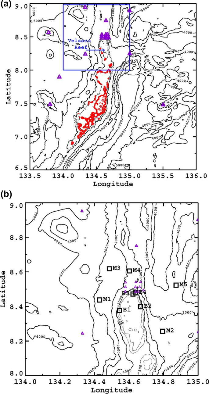
Current and hydrographic measurements were made in the equatorial Pacific Ocean between the westward-flowing North Equatorial Current and the eastward-flowing North Equatorial Counter Current. Nine moorings containing current profilers and hydrographic sensors were deployed on and around Velasco Reef, just north of Palau Island, from May 2016 to March 2017, when the Pacific Ocean was relaxing after the 2015/16 El Niño. Currents and their interactions with this abrupt bathymetric feature are characterized on spatial scales of 10–30 km, and frequencies from semidiurnal to intraseasonal. Currents near the reef displayed a two-layer structure and were not stationary due to the shifting of the major currents and eddy passages. Energy was significant at tidal and inertial periods, and at periods longer than ten days. Tides and higher frequency currents were responsible for about half the energy on the reef but for only about 20% of the energy in the deep water. Cyclonic (anticyclonic) vorticity occurred on the western (eastern) side of the reef during westward (eastward) flows, indicating recirculation on the leeward side of the reef. Vorticity west of the reef was much stronger than vorticity on the east side. When the cyclonic vorticity was large, the divergence flow patterns supported strong upwelling in the upper layer. Differences in both vertical and horizontal velocity coherences and correlations between moorings indicated that the reef affected the currents. The reef seemed to significantly impact water exchange. Currents near the reef are difficult to be described, particularly at depth by satellite products, making their prediction problematic.
中文翻译:
深海岛屿/珊瑚礁及其周围的当前观测:帕劳北部和贝拉斯科礁
在向西流动的北赤道洋流和向东流动的北赤道逆流之间的赤道太平洋进行了洋流和水文测量。从 2016 年 5 月到 2017 年 3 月,当太平洋在 2015/16 年厄尔尼诺现象之后正在放松时,在帕劳岛以北的贝拉斯科礁及其周围部署了 9 个包含电流剖面仪和水文传感器的系泊设备。洋流及其与这种突然的测深特征的相互作用以 10-30 公里的空间尺度为特征,频率从半日到季节内。珊瑚礁附近的洋流呈现出两层结构,并且由于主要洋流和涡流通道的移动而不是静止的。在潮汐和惯性时期以及超过十天的时期,能量是显着的。潮汐和更高频率的水流占珊瑚礁能量的一半左右,但仅占深水能量的约 20%。在向西(向东)流动的过程中,在礁的西(东)侧发生了气旋(反气旋)涡度,表明在礁的背风侧发生了再循环。礁体西侧的涡度比东侧的涡度强得多。当气旋涡度较大时,发散流型支持上层强烈的上升流。系泊之间的垂直和水平速度相干性和相关性的差异表明珊瑚礁影响了水流。珊瑚礁似乎对水交换产生了重大影响。珊瑚礁附近的水流很难描述,特别是卫星产品的深度,这使得它们的预测存在问题。


 京公网安备 11010802027423号