Earth-Science Reviews ( IF 10.8 ) Pub Date : 2022-05-31 , DOI: 10.1016/j.earscirev.2022.104069 Derrick Hasterok , Jacqueline A. Halpin , Alan S. Collins , Martin Hand , Corné Kreemer , Matthew G. Gard , Stijn Glorie
|
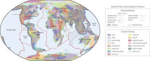
Accurate spatial models of tectonic plates and geological terranes are important for analyzing and interpreting a wide variety of geoscientific data and developing compositional and physical models of the lithosphere. We present a global compilation of active plate boundaries and geological provinces in a shapefile format with interpretive attributes (e.g., crust type, plate type, province type, last orogeny). The initial plate and province boundaries are constructed from a combination of published global and regional models that we refine using a variety of geoscientific constraints including, but not limited to, relative GPS motions, earthquakes, mapped faults, potential field characteristics, and geochronology. These new plate model show improved correlation to observed earthquake and volcano occurrences within deformation zones and microplates, compared to existing models, capturing 73 and 80% of these criteria, respectively. Deformation zones and microplates only account for 16% of Earth's surface area. We estimate 57.5% of the Earth's surface is covered by oceanic crust, which is a slight increase relative to the most recent seafloor age model. The model of last orogenies agrees well with peaks in the globally summed geochronology data. There is room for improvement in future editions of our global plate and geologic provinces model where basins, ice, or lack of geological data fidelity obscure bedrock geology, particularly in the eastern Central Asian Orogenic Belt, much of Africa, East Antarctica, and eastern Australia. Additionally, some province types—orogens, shields, and cratons that are homogenized within our global scheme—can likely be partitioned into smaller terranes with more precise geodynamic attributes. Despite some of these shortcomings, the digital maps presented here form a self-consistent data standard for adding spatial metadata to geoscientific databases. The database is available on GitHub where the geoscience community can provide updates to improve the models and their contemporaneity as new knowledge is acquired. The files are also released in formats suitable for use in Generic Mapping Tools and GoogleEarth.
中文翻译:
全球地质省份和构造板块新图
构造板块和地质地体的准确空间模型对于分析和解释各种地球科学数据以及开发岩石圈的成分和物理模型非常重要。我们以具有解释属性(例如,地壳类型、板块类型、省份类型、最后造山运动)的 shapefile 格式呈现活动板块边界和地质省份的全球汇编。最初的板块和省份边界是由已发表的全球和区域模型的组合构建的,我们使用各种地球科学约束来改进这些模型,包括但不限于相对 GPS 运动、地震、映射断层、势场特征和地质年代学。这些新的板块模型显示出与变形带和微板块内观测到的地震和火山事件的相关性得到改善,与现有模型相比,分别满足了这些标准的 73% 和 80%。变形带和微板块仅占地球表面积的 16%。我们估计地球表面的 57.5% 被洋壳覆盖,与最近的海底年龄模型相比略有增加。最后一次造山运动模型与全球总和地质年代学数据中的峰值非常吻合。在我们的全球板块和地质省份模型的未来版本中存在改进的空间,其中盆地、冰或缺乏保真地质数据使基岩地质模糊不清,特别是在中亚造山带东部、非洲大部分地区、南极洲东部和澳大利亚东部. 此外,一些省份类型——造山带、盾牌、在我们的全球方案中均质化的克拉通和克拉通很可能被划分为具有更精确地球动力学属性的较小地体。尽管存在这些缺点,但这里介绍的数字地图形成了一个自洽的数据标准,用于将空间元数据添加到地球科学数据库。该数据库可在 GitHub 上获得,地球科学社区可以在其中提供更新,以在获得新知识时改进模型及其同时性。这些文件还以适合在通用地图工具和 GoogleEarth 中使用的格式发布。该数据库可在 GitHub 上获得,地球科学社区可以在其中提供更新,以在获得新知识时改进模型及其同时性。这些文件还以适合在通用地图工具和 GoogleEarth 中使用的格式发布。该数据库可在 GitHub 上获得,地球科学社区可以在其中提供更新,以在获得新知识时改进模型及其同时性。这些文件还以适合在通用地图工具和 GoogleEarth 中使用的格式发布。


 京公网安备 11010802027423号