Ecological Indicators ( IF 7.0 ) Pub Date : 2022-03-12 , DOI: 10.1016/j.ecolind.2022.108765 Jing Wang 1, 2 , Pingda Lu 1, 2 , Donatella Valente 3 , Irene Petrosillo 3 , Subhash Babu 4 , Shiying Xu 1, 2 , Changcheng Li 1, 2 , Donglin Huang 1 , Mengyun Liu 1, 2

|
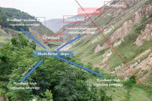
Soil is an essentially limited natural resource that natural and human-induced processes have both generated and damaged. Soil degradation has become one of the most crucial socio-economic and environmental problems since it produces deterioration in productivity and quality of soil resources. Soil erosion, a natural phenomenon that causes degradation of soil and, curves the soil surface away from natural physical forces. To reveal the main factors influencing the spatial distribution of soil erosion in the small watershed of the Loess Plateau, the present study has investigated the synergistic as well as the independent influence of land use, vegetation coverage, and slope on the spatial distribution characteristics of soil erosion in the Wangdonggou watershed in 2015. Soil samples have been collected and analyzed in the laboratory together with high-resolution satellite imagery and meteorological data and derived data from digital elevation model (DEM). The results have shown that soil erosion in Wangdonggou watershed in 2015 has been characterized by a slight erosion, highlighting a gradually increased intensity from North to South. Among different land-uses, woodland and grassland have caused more than 50% soil erosion in the study area, and the areas with vegetation coverage of ≥ 50% have been the main source of soil erosion, and they have been all affected by slope. Furthermore, the practice of expanding vegetation presence on the lower coverage of woodland and grassland, particularly where the slope is between 15°∼45°, and converting sloping woodland and grassland to the terrace have seemed to be effective strategies for controlling soil erosion in the Wangdonggou watershed. Finally, the current study has revealed that the RUSLE-GIS integrated model could be a useful tool to quantitatively and spatially map soil erosion at the watershed scale in the Loess Plateau, taking into account the provision of landscape services.


 京公网安备 11010802027423号