Ecological Indicators ( IF 7.0 ) Pub Date : 2021-10-23 , DOI: 10.1016/j.ecolind.2021.108319
Xinxin Huang 1 , Haijun Wang 1, 2 , Luyi Shan 3 , Fengtao Xiao 4
|
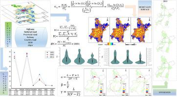
The construction of the urban ecological network has a comprehensive effect on urban aesthetics, society and economy, and provides the driving force for urban sustainable development. However, we found few studies on constructing and optimizing urban ecological networks in cities with the highest human density. In this paper, landscape pattern indexes were applied to analyze the landscape characteristics and morphological pattern analysis (MSPA) to identify the ecological source, the landscape connectivity and the region attributes revised the ecological resistance surface, and urban ecological network was constructed by MCR model. The results show that: (1) many ecological land types mainly distributed in the tributaries of the Yangtze River, while only forest land and water areas occupied in the northwest are. (2) Compared with 1995 and 2005, the number of ecological corridors in 2015 was decreasing. Although the ecological connectivity was improved, which of the Yangtze River was limited. (3) The coordinated development and the ecological protection ecological network optimization plan would promote the connectivity of the urban ecological functioning stability. This study provides recommendations for the optimization of the urban ecological network, which are of great significance for protecting biodiversity, improving ecosystem functions, and maintaining the regional ecological security pattern.
中文翻译:
快速城镇化背景下构建优化城市生态网络提升景观连通性
城市生态网络的建设对城市美学、社会和经济产生综合影响,为城市可持续发展提供动力。然而,我们发现很少有关于在人口密度最高的城市构建和优化城市生态网络的研究。本文应用景观格局指标分析景观特征和形态格局分析(MSPA),识别生态源,景观连通性和区域属性修正生态阻力面,并利用MCR模型构建城市生态网络。结果表明:(1)生态用地类型较多,主要分布在长江支流,而仅占西北地区的林地和水域。(2) 与 1995 年和 2005 年相比,2015年生态廊道数量在减少。虽然生态连通性得到改善,但长江的生态连通性是有限的。(3)协调发展和生态保护生态网络优化规划将促进城市生态功能稳定的连通性。本研究为优化城市生态网络提供了建议,对保护生物多样性、改善生态系统功能、维护区域生态安全格局具有重要意义。(3)协调发展和生态保护生态网络优化规划将促进城市生态功能稳定的连通性。本研究为优化城市生态网络提供了建议,对保护生物多样性、改善生态系统功能、维护区域生态安全格局具有重要意义。(3)协调发展和生态保护生态网络优化规划将促进城市生态功能稳定的连通性。本研究为优化城市生态网络提供了建议,对保护生物多样性、改善生态系统功能、维护区域生态安全格局具有重要意义。


 京公网安备 11010802027423号