Science of the Total Environment ( IF 8.2 ) Pub Date : 2021-04-06 , DOI: 10.1016/j.scitotenv.2021.146932 Sankaran Rajendran , Hamad Al-Saad Al-Kuwari , Fadhil N. Sadooni , Sobi Nasir , Himanshu Govil

|
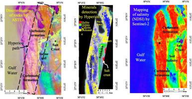
The inland sabkha of the Arabian Gulf is important to study for the occurrence of minerals, rocks, soil salinity, and stability of the sabkha due to the high demand for infrastructure and agriculture development region. This study describes the spectral absorptions of evaporite minerals, discriminates rocks, maps salt crusts, gypsiferous soil flats, and soil salinity, and studies the temporal stability of an inland sabkha of the Dukhan area, west coast of the State of Qatar. This was performed using satellite data of the Hyperion of EO1, ASTER of Terra, and multispectral instrument (MSI) of Sentinel-2. The occurrence of minerals in the area is detected using Hyperion data by the linear spectral unmixing (LSU) method and studied for their spatial distribution. The different geological formations of the sabkha were discriminated by using the VNIR (visible and near-infrared) and SWIR (shortwave infrared) spectral bands from ASTER by principal component analysis (PCA). The image developed by using the principal components (R:PC2, G:PC3, B:PC5) showed the formations in different tones. Salinity of the area was mapped using monthly data of MSI from 2018 to 2020 by normalized difference salinity index (NDSI) (band11-band12) / (band11 + band12). The results of the index displayed the distribution of salinity in the area. Besides, moisture of the area was studied by using the normalized difference moisture index (NDMI) (b8-b11) / (b8 + b11) and described the temporal stability of the sabkha. All the results of image analyses were validated through field and laboratory studies. The study of laboratory spectra of evaporite minerals namely gypsum, anhydrite, and halite present in the salt crusts and gypsiferous soil flats showed their unique spectral absorptions in between 1.4 and 1.5 μm and 1.9–2.0 μm whereas, the calcite and dolomite minerals of the carbonate formations exhibited deep absorptions near 2.345 and 2.495 μm respectively.
中文翻译:

内陆Sabkha遥感和盐度和时间稳定性促进可持续发展的研究:以卡塔尔西海岸为例
由于对基础设施和农业发展地区的需求很高,阿拉伯湾的内陆sabkha对于研究矿物,岩石,土壤盐分和sabkha的稳定性至关重要。这项研究描述了蒸发矿物质的光谱吸收,区分岩石,绘制盐结皮,石膏形土壤平整度和土壤盐度,并研究了卡塔尔州西海岸杜汉地区内陆萨布卡的时间稳定性。这是使用EO1的Hyperion,Terra的ASTER和Sentinel-2的多光谱仪器(MSI)的卫星数据执行的。使用Hyperion数据通过线性光谱分解(LSU)方法检测该地区矿物质的存在,并研究其空间分布。通过使用ASTER的VNIR(可见和近红外)和SWIR(短波红外)光谱带,通过主成分分析(PCA)来区分sabkha的不同地质构造。使用主要成分(R:PC2,G:PC3,B:PC5)显影的图像显示出不同色调的形成。使用2018年至2020年MSI的月度数据,通过归一化差异盐度指数(NDSI)(band11-band12)/(band11 + band12)绘制了该地区的盐度。该指数的结果显示了该地区的盐度分布。此外,通过使用归一化差异水分指数(NDMI)(b8-b11)/(b8 + b11)研究了该地区的水分,并描述了萨布卡人的时间稳定性。图像分析的所有结果均通过现场和实验室研究进行了验证。


 京公网安备 11010802027423号