Earth, Planets and Space ( IF 3.0 ) Pub Date : 2021-04-01 , DOI: 10.1186/s40623-021-01400-9
Matthew J Comeau 1 , Michael Becken 1 , Alexey V Kuvshinov 2 , Sodnomsambuu Demberel 3
|
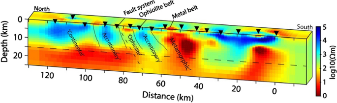
Crustal architecture strongly influences the development and emplacement of mineral zones. In this study, we image the crustal structure beneath a metallogenic belt and its surroundings in the Bayankhongor area of central Mongolia. In this region, an ophiolite belt marks the location of an ancient suture zone, which is presently associated with a reactivated fault system. Nearby, metamorphic and volcanic belts host important mineralization zones and constitute a significant metallogenic belt that includes sources of copper and gold. However, the crustal structure of these features, and their relationships, are poorly studied. We analyze magnetotelluric data acquired across this region and generate three-dimensional electrical resistivity models of the crustal structure, which is found to be locally highly heterogeneous. Because the upper crust (< 25 km) is found to be generally highly resistive (> 1000 Ωm), low-resistivity (< 50 Ωm) features are conspicuous. Anomalous low-resistivity zones are congruent with the suture zone, and ophiolite belt, which is revealed to be a major crustal-scale feature. Furthermore, broadening low-resistivity zones located down-dip from the suture zone suggest that the narrow deformation zone observed at the surface transforms to a wide area in the deeper crust. Other low-resistivity anomalies are spatially associated with the surface expressions of known mineralization zones; thus, their links to deeper crustal structures are imaged. Considering the available evidence, we determine that, in both cases, the low resistivity can be explained by hydrothermal alteration along fossil fluid pathways. This illustrates the pivotal role that crustal fluids play in diverse geological processes, and highlights their inherent link in a unified system, which has implications for models of mineral genesis and emplacement. The results demonstrate that the crustal architecture—including the major crustal boundary—acts as a first‐order control on the location of the metallogenic belt.
中文翻译:
成矿带和蛇绿岩带的地壳结构:3-D 电阻率模型对矿物成因和就位的影响(蒙古巴彦洪戈尔地区)
地壳结构强烈影响矿区的发展和就位。在这项研究中,我们对蒙古中部巴彦洪戈尔地区成矿带及其周围环境下的地壳结构进行了成像。在该地区,蛇绿岩带标志着古代缝合带的位置,该缝合带目前与重新激活的断层系统有关。附近的变质和火山带拥有重要的矿化带,构成了一个重要的成矿带,其中包括铜和金的来源。然而,对这些特征的地壳结构及其关系的研究很少。我们分析了在该区域获得的大地电磁数据,并生成了地壳结构的三维电阻率模型,该模型被发现是局部高度异质的。由于发现上地壳(<25 km)通常具有高电阻(> 1000 Ωm),因此低电阻率(< 50 Ωm)特征很明显。异常低电阻率带与缝合带和蛇绿岩带一致,这是地壳尺度的主要特征。此外,位于缝合带下倾的低电阻率带变宽表明,在地表观察到的狭窄变形带转变为更深地壳中的广阔区域。其他低电阻率异常在空间上与已知矿化带的地表表现有关;因此,它们与更深的地壳结构的联系被成像。考虑到现有证据,我们确定,在这两种情况下,低电阻率都可以通过沿化石流体路径的热液改变来解释。这说明了地壳流体在不同地质过程中发挥的关键作用,并突出了它们在统一系统中的内在联系,这对矿物成因和侵位模型具有重要意义。结果表明,地壳结构——包括主要地壳边界——是对成矿带位置的一级控制。


 京公网安备 11010802027423号