当前位置:
X-MOL 学术
›
Hydrol. Process.
›
论文详情
Our official English website, www.x-mol.net, welcomes your feedback! (Note: you will need to create a separate account there.)
The Kiryu Experimental Watershed: 50‐years of rainfall‐runoff data for a forest catchment in central Japan
Hydrological Processes ( IF 2.8 ) Pub Date : 2021-02-24 , DOI: 10.1002/hyp.14104 Masanori Katsuyama 1 , Nobuhito Ohte 2 , Yoshiko Kosugi 2 , Makoto Tani 3
Hydrological Processes ( IF 2.8 ) Pub Date : 2021-02-24 , DOI: 10.1002/hyp.14104 Masanori Katsuyama 1 , Nobuhito Ohte 2 , Yoshiko Kosugi 2 , Makoto Tani 3
Affiliation

|
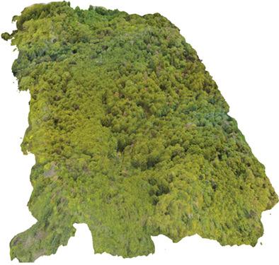
The Kiryu Experimental Catchment (KEW) is a small (5.99 ha) forest catchment located in Shiga Prefecture, central Japan (34°58′ N, 136°00′ E; www.bluemoon.kais.kyoto-u.ac.jp/kiryu/contents.html). Around this area, forest devastation occurred from ca. 1250 to ca. 150 years ago because of overuse of forest and timbers. Then, hillside forestation was carried out for more than 100 years to prevent soil erosion and support the timber industry, and consequently, most of this area is now covered with plantation forests mainly by Chamaecyparis obtusa Sieb. et Zucc. (Japanese cypress) planted around 1960's. This plantation forest is not actively managed. The KEW is one of the leading experimental forests with long‐term monitoring data in Japan. Research in the KEW began in 1967 to elucidate the hydrological and biogeochemical processes in the forested catchment in relation to climate, geology, soil, and vegetation growth. Since then, the long‐term hydrological data of precipitation, runoff and sediment transport are continuously monitoring. In this study, we provide the data and preliminarily discuss the rainfall–runoff patterns and sediment transport through 50 years in the KEW. The annual precipitation and the maximum daily rainfall have been greater than the average over the last decade. In response to the rainfall patterns, the ratio of annual direct runoff to precipitation was also larger in the last decade. The sediment transport in this decade was consequently larger than the preceding decades. Our data presented here suggest that a close relationship exists between the climate condition, rainfall–runoff response, sediment dynamics, as well as a slowly progressing change of forest condition.
中文翻译:

桐生试验流域:日本中部森林流域50年的降雨径流数据
桐生实验流域(KEW)是位于日本中部滋贺县(北纬34°58′,东经136°00′)的小型森林流域(5.99公顷); www.bluemoon.kais.kyoto-u.ac.jp/ kiryu / contents.html)。在该地区附近,大约从1989年开始发生森林破坏。1250至大约 150年前,由于过度使用森林和木材。然后,为了防止水土流失和支持木材工业,进行了超过100年的山坡造林,因此,该地区的大部分地区现在主要由Chamaecyparis obtusa Sieb覆盖着人工林。。et Zucc。(日本柏树)种植于1960年代左右。该人工林未被积极管理。KEW是日本拥有长期监测数据的领先实验森林之一。KEW的研究始于1967年,目的是阐明森林集水区中与气候,地质,土壤和植被生长相关的水文和生物地球化学过程。从那时起,就不断监测降水,径流和泥沙输送的长期水文数据。在这项研究中,我们提供了数据,并初步讨论了KEW在过去50年中的降雨-径流模式和泥沙输送。过去十年中,年降水量和每日最大降水量均高于平均水平。根据降雨情况,在过去十年中,年直接径流量与降水的比例也更大。因此,这十年中的泥沙输送量比之前的几十年要大。我们在此提供的数据表明,气候条件,降雨-径流响应,沉积物动力学以及森林条件的缓慢变化之间存在密切的关系。
更新日期:2021-03-18
中文翻译:

桐生试验流域:日本中部森林流域50年的降雨径流数据
桐生实验流域(KEW)是位于日本中部滋贺县(北纬34°58′,东经136°00′)的小型森林流域(5.99公顷); www.bluemoon.kais.kyoto-u.ac.jp/ kiryu / contents.html)。在该地区附近,大约从1989年开始发生森林破坏。1250至大约 150年前,由于过度使用森林和木材。然后,为了防止水土流失和支持木材工业,进行了超过100年的山坡造林,因此,该地区的大部分地区现在主要由Chamaecyparis obtusa Sieb覆盖着人工林。。et Zucc。(日本柏树)种植于1960年代左右。该人工林未被积极管理。KEW是日本拥有长期监测数据的领先实验森林之一。KEW的研究始于1967年,目的是阐明森林集水区中与气候,地质,土壤和植被生长相关的水文和生物地球化学过程。从那时起,就不断监测降水,径流和泥沙输送的长期水文数据。在这项研究中,我们提供了数据,并初步讨论了KEW在过去50年中的降雨-径流模式和泥沙输送。过去十年中,年降水量和每日最大降水量均高于平均水平。根据降雨情况,在过去十年中,年直接径流量与降水的比例也更大。因此,这十年中的泥沙输送量比之前的几十年要大。我们在此提供的数据表明,气候条件,降雨-径流响应,沉积物动力学以及森林条件的缓慢变化之间存在密切的关系。


 京公网安备 11010802027423号