Science of the Total Environment ( IF 8.2 ) Pub Date : 2020-08-13 , DOI: 10.1016/j.scitotenv.2020.141565 Aman Arora 1 , Alireza Arabameri 2 , Manish Pandey 3 , Masood A Siddiqui 1 , U K Shukla 4 , Dieu Tien Bui 5 , Varun Narayan Mishra 6 , Anshuman Bhardwaj 7
|
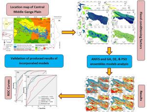
This study is an attempt to quantitatively test and compare novel advanced-machine learning algorithms in terms of their performance in achieving the goal of zonation of predicting flood susceptible areas in a low altitudinal range, sub-tropical floodplain environmental setting like that prevailing in the Middle Ganga Plain (MGP), India. This part of the Ganga floodplain region, which under the influence of undergoing active tectonic regime related subsidence, is the hotbed of annual flood disaster, and is one of the best natural laboratories to test the flood susceptibility models for establishing a universalization of such models in low relief highly flood prone areas. Based on highly sophisticated flood inventory archived for this region, and 12 flood conditioning factors viz. annual rainfall, soil type, stream density, distance from stream, distance from road, Topographic Wetness Index (TWI), altitude, slope aspect, slope, curvature, land use/land cover, and geomorphology, an advanced novel hybrid model Adaptive Neuro Fuzzy Inference System (ANFIS), and three metaheuristic models-based ensembles with ANFIS namely ANFIS-GA (Genetic Algorithm), ANFIS-DE (Differential Evolution), and ANFIS-PSO (Particle Swarm Optimization), have been applied for zonation of the flood susceptible areas. The flood inventory dataset, prepared by satellite based collected flood samples, were apportioned into 70:30 classes to prepare training and validation datasets. One independent validation method, the Area-Under Receiver Operating Characteristic (AUROC) Curve, and other 11 cut-off-dependent model evaluation metrices have helped to conclude that the ANIFS-GA has outhustled other three models with highest success rate AUC = 0.922 and prediction rate AUC = 0.924. The accuracy was also found highest for ANFIS-GA during training (0.886) & validation (0.883). Better performance of ANIFS-GA than the individual models as well as some ensemble models suggests and warrants further study in this topoclimatic environment using other classes of susceptibility models for the purpose of establishing a benchmark model with capability of highest accuracy and sensitivity performance in the similar topographic and climatic setting taking assumption of the quality of input parameters as constant.
中文翻译:
基于最新的基于模糊变磁学ANFIS的机器学习模型的优化,用于印度中部恒河平原的洪水敏感性预测。
这项研究试图对新型高级机器学习算法进行性能测试和比较,以实现其在低海拔范围,亚热带洪泛平原环境设置(如中部盛行)中预测洪灾敏感地区的目标。印度,恒河平原(MGP)。恒河洪泛区的这一部分在经历活跃的构造体制相关沉降的影响下,是一年一度的洪水灾害的温床,并且是测试洪水敏感性模型的最佳自然实验室之一,以建立这种模型的普遍性。低救济,高洪灾地区。基于为该地区存档的高度复杂的洪水清单,以及12个洪水调节因子。年降雨量,土壤类型,河流密度,与河流的距离,距道路的距离,地形湿度指数(TWI),高度,坡度,坡度,曲率,土地利用/土地覆盖和地貌,先进的新型混合模型自适应神经模糊推理系统(ANFIS)以及三个基于元启发式模型的集成体借助ANFIS,即ANFIS-GA(遗传算法),ANFIS-DE(差分演化)和ANFIS-PSO(粒子群优化),已将其用于洪水敏感区域的分区。由卫星收集的洪水样本准备的洪水清单数据集按70:30类别分配,以准备训练和验证数据集。一种独立的验证方法,即接收器下面积工作特性(AUROC)曲线,以及其他11个与截止值相关的模型评估指标,可以得出结论,ANIFS-GA的成功率AUC = 0.922,预测率AUC = 0.924,已经超过了其他三个模型。在培训(0.886)和验证(0.883)期间,ANFIS-GA的准确性也最高。ANIFS-GA的性能要优于单个模型和某些整体模型,这表明并需要在此地形气候环境中使用其他类别的磁化率模型进行进一步研究,以建立一个基准模型,从而在同类环境中具有最高的准确性和灵敏度。假设输入参数的质量不变的地形和气候设置。在培训(0.886)和验证(0.883)期间,ANFIS-GA的准确性也最高。ANIFS-GA的性能要优于单个模型和某些整体模型,这表明并需要在此地形气候环境中使用其他类别的磁化率模型进行进一步研究,以建立一个基准模型,从而在同类环境中具有最高的准确性和灵敏度。假设输入参数的质量不变的地形和气候设置。在培训(0.886)和验证(0.883)期间,ANFIS-GA的准确性也最高。ANIFS-GA的性能要优于单个模型和某些整体模型,这表明并需要在此地形气候环境中使用其他类别的磁化率模型进行进一步研究,以建立一个基准模型,从而在同类环境中具有最高的准确性和灵敏度。假设输入参数的质量不变的地形和气候设置。


 京公网安备 11010802027423号