Science of the Total Environment ( IF 8.2 ) Pub Date : 2020-05-26 , DOI: 10.1016/j.scitotenv.2020.139721 Pinglang Kou 1 , Qiang Xu 1 , Ali P Yunus 1 , Xiujun Dong 1 , Chuanhao Pu 1 , Xiaochao Zhang 1 , Zhao Jin 2

|
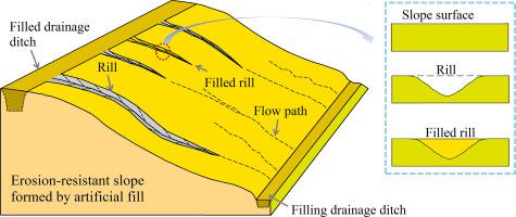
Due to urban expansion and the rapid development of infrastructure in the loess area of China, artificial earth-fill embankments and excavated slopes are increasingly widespread in recent years. Erosion is typical in such loess slopes; however, quantitative statistical analyses of various counter-measures that affects rill erosion are still lacking. Here, we quantified rill morphology and rill erosion development in two newly constructed slopes with different engineering protection measures. We used high-resolution digital surface models (DSMs) acquired using an Unmanned Aerial Vehicle (UAV) to analyze the case areas during two-time periods. Our results from centimeter accuracy differential DSMs demonstrated that rapid rill erosion is prevalent in the study area, expressed as rill density varying between 2.03 km−2 and 8.81 km−2 at different slope surfaces (viz., erosion protected slopes [EPS], landslide protected slopes [LPS], and unprotected slopes [US]). The slope gradient responsible for rill erosion of the EPS, LPS and US are obviously different, and such information is essential for planning preventive measures in each slope type. At the EPS, the severity of erosion is maximum at the top of the ridges, whereas the gap between reinforced concrete lattice and loess deposits are of serious concern at the LPS. The current engineering measures employed in the study area are thus found ineffective for protection against rill erosion. We therefore propose an improved design by implementing an intercepting drain to the existing design for preventing further erosion.


 京公网安备 11010802027423号