当前位置:
X-MOL 学术
›
Int. J. Climatol.
›
论文详情
Our official English website, www.x-mol.net, welcomes your feedback! (Note: you will need to create a separate account there.)
Downscaling climate projections over large and data sparse regions: Methodological application in the Zambezi River Basin
International Journal of Climatology ( IF 3.5 ) Pub Date : 2020-04-03 , DOI: 10.1002/joc.6578 Nadav Peleg 1 , Scott Sinclair 1 , Simone Fatichi 1, 2 , Paolo Burlando 1
International Journal of Climatology ( IF 3.5 ) Pub Date : 2020-04-03 , DOI: 10.1002/joc.6578 Nadav Peleg 1 , Scott Sinclair 1 , Simone Fatichi 1, 2 , Paolo Burlando 1
Affiliation
|
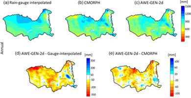
Climate impact studies often require climate data at a higher space–time resolution than is available from global and regional climate models. Weather generator (WG) models, generally designed for mesoscale applications (e.g., 101–105 km2), are popular and widely used tools to downscale climate data to finer resolution. One advantage of using WGs is their ability to generate the necessary climate variables for impact studies in data sparse regions. In this study, we evaluate the ability of a previously established state of the art WG (the AWE‐GEN‐2d model) to perform in data sparse regions that are beyond the mesoscale, using the Zambezi River basin (106 km2) in southeast Africa as a case study. The AWE‐GEN‐2d model was calibrated using data from satellite retrievals and climate re‐analysis products in place of the absent observational data. An 8‐km climate ensemble at hourly resolution, covering the period of 1976–2099 (present climate and RCP4.5 emission scenario from 2020), was then simulated. Using the simulated 30‐member ensemble, climate indices for both present and future climates were computed. The high‐resolution climate indices allow detailed analysis of the effects of climate change on different areas within the basin. For example, the southwestern area of the basin is predicted to experience the greatest change due to increased temperature, while the southeastern area was found to be already so hot that is less affected (e.g., the number of 'very hot days' per year increase by 18 and 9 days, respectively). Rainfall intensities are found to increase most in the eastern areas of the basin (1 mm·d−1) in comparison to the western region (0.3 mm·d−1). As demonstrated in this study, AWE‐GEN‐2d can be calibrated successfully using data from climate reanalysis products in the absence of ground station data and can be applied at larger scales than the mesoscale.
中文翻译:

大型和数据稀疏区域的降尺度气候预测:方法在赞比西河流域的应用
与全球和区域气候模型相比,气候影响研究通常需要更高时空分辨率的气候数据。通常用于中尺度应用(例如10 1 – 10 5 km 2)的天气生成器(WG)模型是流行的和广泛使用的工具,用于将气候数据缩减到更高分辨率。使用工作组的优势之一是它们能够生成必要的气候变量,以进行数据稀疏地区的影响研究。在这项研究中,我们使用赞比西河流域(10 6 km 2)评估了先前建立的最先进工作组(AWE‐GEN-2d模型)在中尺度以外的数据稀疏区域中执行数据的能力。)作为案例研究。使用卫星检索和气候再分析产品中的数据代替缺少的观测数据对AWE‐GEN-2d模型进行了校准。然后,模拟了一个按小时分辨率划分的8公里的气候集合,涵盖了1976-2099年(从2020年开始的当前气候和RCP4.5排放情景)。使用模拟的30人集合,计算了当前和未来气候的气候指数。高分辨率的气候指数可以详细分析气候变化对流域内不同区域的影响。例如,由于温度升高,预计盆地西南部地区将经历最大的变化,而东南部地区则已经如此炎热以至于受影响较小(例如,“非常热的天数” 每年分别增加18天和9天)。发现流域东部地区的降雨强度增加最多(1 mm·d-1)与西部地区(0.3 mm·d -1)相比。如本研究所示,在没有地面站数据的情况下,AWE‐GEN-2d可以使用气候再分析产品中的数据成功进行校准,并且可以在比中尺度更大的尺度上应用。
更新日期:2020-04-03
中文翻译:
大型和数据稀疏区域的降尺度气候预测:方法在赞比西河流域的应用
与全球和区域气候模型相比,气候影响研究通常需要更高时空分辨率的气候数据。通常用于中尺度应用(例如10 1 – 10 5 km 2)的天气生成器(WG)模型是流行的和广泛使用的工具,用于将气候数据缩减到更高分辨率。使用工作组的优势之一是它们能够生成必要的气候变量,以进行数据稀疏地区的影响研究。在这项研究中,我们使用赞比西河流域(10 6 km 2)评估了先前建立的最先进工作组(AWE‐GEN-2d模型)在中尺度以外的数据稀疏区域中执行数据的能力。)作为案例研究。使用卫星检索和气候再分析产品中的数据代替缺少的观测数据对AWE‐GEN-2d模型进行了校准。然后,模拟了一个按小时分辨率划分的8公里的气候集合,涵盖了1976-2099年(从2020年开始的当前气候和RCP4.5排放情景)。使用模拟的30人集合,计算了当前和未来气候的气候指数。高分辨率的气候指数可以详细分析气候变化对流域内不同区域的影响。例如,由于温度升高,预计盆地西南部地区将经历最大的变化,而东南部地区则已经如此炎热以至于受影响较小(例如,“非常热的天数” 每年分别增加18天和9天)。发现流域东部地区的降雨强度增加最多(1 mm·d-1)与西部地区(0.3 mm·d -1)相比。如本研究所示,在没有地面站数据的情况下,AWE‐GEN-2d可以使用气候再分析产品中的数据成功进行校准,并且可以在比中尺度更大的尺度上应用。


 京公网安备 11010802027423号