Our official English website, www.x-mol.net, welcomes your
feedback! (Note: you will need to create a separate account there.)
Multi-model Hydroclimate Projections for the Alabama-Coosa-Tallapoosa River Basin in the Southeastern United States.
Scientific Reports ( IF 3.8 ) Pub Date : 2020-02-18 , DOI: 10.1038/s41598-020-59806-6 Sudershan Gangrade 1, 2, 3 , Shih-Chieh Kao 1, 2, 3 , Ryan A McManamay 4
Scientific Reports ( IF 3.8 ) Pub Date : 2020-02-18 , DOI: 10.1038/s41598-020-59806-6 Sudershan Gangrade 1, 2, 3 , Shih-Chieh Kao 1, 2, 3 , Ryan A McManamay 4
Affiliation

|
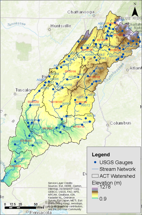
This study uses a high-resolution, process-based modeling framework to assess the impacts of changing climate on water resources for the Alabama-Coosa-Tallapoosa River Basin in the southeastern United States. A 33-member ensemble of hydrologic projections was generated using 3 distributed hydrologic models (Precipitation-Runoff Modeling System, Variable Infiltration Capacity, and Distributed Hydrology Soil Vegetation Model) of different complexity. These hydrologic models were driven by dynamically downscaled and bias-corrected future climate simulations from 11 Coupled Model Intercomparison Project Phase 5 global climate models under Representative Concentration Pathway 8.5 emission scenario, with 40 years each in baseline (1966-2005) and future (2011-2050) periods. The hydroclimate response, in general, projects an increase in mean seasonal precipitation, runoff, and streamflow. The high and low flows are projected to increase and decrease, respectively, in general, suggesting increased likelihood of extreme rainfall events and intensification of the hydrologic cycle. The uncertainty associated with the ensemble hydroclimate response, analyzed through an analysis of variance technique, suggests that the choice of climate model is more critical than the choice of hydrologic model for the studied region. This study provides in-depth insights of hydroclimate response and associated uncertainties to support informed decisions by water resource managers.
中文翻译:

美国东南部阿拉巴马州-库萨-塔拉普萨市流域的多模式水文气候投影。
这项研究使用高分辨率的基于过程的建模框架来评估气候变化对美国东南部阿拉巴马州-库萨-塔拉波萨河流域的水资源的影响。使用3种复杂程度不同的分布式水文模型(降水-径流模型系统,可变入渗能力和分布式水文土壤植被模型)生成了一个由33名成员组成的水文投影集合。这些水文模型由代表比例途径8.5排放情景下11个耦合模型比对项目第5阶段全球气候模型的动态缩小规模和偏差校正的未来气候模拟驱动,在基线(1966-2005年)和未来(2011-2005年)中各有40年2050年)。一般来说,水气候响应 预计平均季节降水,径流量和水流量将增加。总体上,预计高流量和低流量分别增加和减少,这表明极端降雨事件和水文循环加剧的可能性增加。通过方差分析法分析的与整体水气候响应有关的不确定性表明,对于研究区域而言,气候模型的选择比水文模型的选择更为关键。这项研究提供了对水气候响应和相关不确定性的深入见解,以支持水资源管理者的明智决策。表明极端降雨事件和水文循环加剧的可能性增加。通过方差分析法分析的与整体水气候响应有关的不确定性表明,对于研究区域而言,气候模型的选择比水文模型的选择更为关键。这项研究提供了对水气候响应和相关不确定性的深入见解,以支持水资源管理者的明智决策。表明极端降雨事件和水文循环加剧的可能性增加。通过方差分析法分析的与整体水气候响应有关的不确定性表明,对于研究区域而言,气候模型的选择比水文模型的选择更为关键。这项研究提供了对水气候响应和相关不确定性的深入见解,以支持水资源管理者的明智决策。
更新日期:2020-02-18
中文翻译:

美国东南部阿拉巴马州-库萨-塔拉普萨市流域的多模式水文气候投影。
这项研究使用高分辨率的基于过程的建模框架来评估气候变化对美国东南部阿拉巴马州-库萨-塔拉波萨河流域的水资源的影响。使用3种复杂程度不同的分布式水文模型(降水-径流模型系统,可变入渗能力和分布式水文土壤植被模型)生成了一个由33名成员组成的水文投影集合。这些水文模型由代表比例途径8.5排放情景下11个耦合模型比对项目第5阶段全球气候模型的动态缩小规模和偏差校正的未来气候模拟驱动,在基线(1966-2005年)和未来(2011-2005年)中各有40年2050年)。一般来说,水气候响应 预计平均季节降水,径流量和水流量将增加。总体上,预计高流量和低流量分别增加和减少,这表明极端降雨事件和水文循环加剧的可能性增加。通过方差分析法分析的与整体水气候响应有关的不确定性表明,对于研究区域而言,气候模型的选择比水文模型的选择更为关键。这项研究提供了对水气候响应和相关不确定性的深入见解,以支持水资源管理者的明智决策。表明极端降雨事件和水文循环加剧的可能性增加。通过方差分析法分析的与整体水气候响应有关的不确定性表明,对于研究区域而言,气候模型的选择比水文模型的选择更为关键。这项研究提供了对水气候响应和相关不确定性的深入见解,以支持水资源管理者的明智决策。表明极端降雨事件和水文循环加剧的可能性增加。通过方差分析法分析的与整体水气候响应有关的不确定性表明,对于研究区域而言,气候模型的选择比水文模型的选择更为关键。这项研究提供了对水气候响应和相关不确定性的深入见解,以支持水资源管理者的明智决策。


 京公网安备 11010802027423号