当前位置:
X-MOL 学术
›
Remote Sens. Environ.
›
论文详情
Our official English website, www.x-mol.net, welcomes your
feedback! (Note: you will need to create a separate account there.)
Polygon-Informed Cross-Track Altimetry (PICTA): Estimating river water level profiles with the Sentinel-6 altimeter
Remote Sensing of Environment ( IF 11.1 ) Pub Date : 2024-11-01 , DOI: 10.1016/j.rse.2024.114479 Frithjof Ehlers, Cornelis Slobbe, Florian Schlembach, Marcel Kleinherenbrink, Martin Verlaan
Remote Sensing of Environment ( IF 11.1 ) Pub Date : 2024-11-01 , DOI: 10.1016/j.rse.2024.114479 Frithjof Ehlers, Cornelis Slobbe, Florian Schlembach, Marcel Kleinherenbrink, Martin Verlaan

|
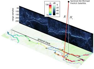
Traditionally, nadir-looking satellite radar altimeters provide water levels of rivers only at intersections with the satellite’s ground track, called virtual stations. These observations have limited spatial coverage because such cross-overs are sparse, depending on the altimeter’s orbit. In this work, we introduce the novel concept of Polygon-Informed Cross-Track Altimetry (PICTA), enabling accurate estimation of water levels at cross-track distances — for as long as the target’s signal is recorded in the altimeter’s range window. Using fully-focused SAR data from the Sentinel-6 altimetry mission, we demonstrate how the new approach can provide detailed river water level profiles over a ground swath of about 14 km cross-track width and with an along-track resolution as fine as 10 m. On the one hand, this marks a drastic improvement in the number of available measurements when compared to the virtual station approach, on the other hand, for the first time, water surface slopes and level variations along the river, caused by rapids, dams, and sluices, can be directly observed using a nadir radar altimeter. The validation over two river segments in France reveals biases as low as ± 4
中文翻译:

多边形信息跨轨测高仪 (PICTA):使用 Sentinel-6 高度计估算河流水位剖面
传统上,看起来像最低点的卫星雷达高度计仅在与卫星地面轨道(称为虚拟站)的交叉点提供河流的水位。这些观测值的空间覆盖范围有限,因为此类交叉点很稀疏,具体取决于高度计的轨道。在这项工作中,我们引入了多边形信息跨轨高度计 (PICTA) 的新概念,只要目标的信号记录在高度计的范围窗口中,就可以准确估计交叉轨道距离的水位。使用来自 Sentinel-6 测高任务的全聚焦 SAR 数据,我们展示了新方法如何在约 14 公里的交叉轨道宽度的地面上提供详细的河流水位剖面,并具有高达 10 m 的沿轨道分辨率。一方面,与虚拟站方法相比,这标志着可用测量的数量有了很大的提高,另一方面,第一次可以使用最低点雷达高度计直接观测由急流、水坝和水闸引起的沿河水面坡度和水位变化。对法国两条河段的验证显示,在沿轨道分辨率 30 m 处,偏差低至 ±4 cm,随机误差约为 3-8 cm。新的 PICTA 概念有可能推广到其他目标,例如湖泊甚至海岸线。
更新日期:2024-11-01
中文翻译:

多边形信息跨轨测高仪 (PICTA):使用 Sentinel-6 高度计估算河流水位剖面
传统上,看起来像最低点的卫星雷达高度计仅在与卫星地面轨道(称为虚拟站)的交叉点提供河流的水位。这些观测值的空间覆盖范围有限,因为此类交叉点很稀疏,具体取决于高度计的轨道。在这项工作中,我们引入了多边形信息跨轨高度计 (PICTA) 的新概念,只要目标的信号记录在高度计的范围窗口中,就可以准确估计交叉轨道距离的水位。使用来自 Sentinel-6 测高任务的全聚焦 SAR 数据,我们展示了新方法如何在约 14 公里的交叉轨道宽度的地面上提供详细的河流水位剖面,并具有高达 10 m 的沿轨道分辨率。一方面,与虚拟站方法相比,这标志着可用测量的数量有了很大的提高,另一方面,第一次可以使用最低点雷达高度计直接观测由急流、水坝和水闸引起的沿河水面坡度和水位变化。对法国两条河段的验证显示,在沿轨道分辨率 30 m 处,偏差低至 ±4 cm,随机误差约为 3-8 cm。新的 PICTA 概念有可能推广到其他目标,例如湖泊甚至海岸线。


 京公网安备 11010802027423号